Washington Map Society
Sander's Carto Notes
Rather than expect Portolan readers to type character links or URL's (running from 15 to 150 characters) to articles mentioned in Tom Sander's Cartographic Notes, below we reproduce the links for volumes 86-97. Just click on the URL (link address) or, depending on your browser and OS, you may need to copy and past the URL into your browser address bar. The links are accurate at the time of our publication.
CORRESPONDENCE or ADDRESS/E-MAIL CHANGES TO THE
WASHINGTON MAP SOCIETY
The Society may be contacted in two ways.
For any Portolan-related correspondence, please send your inquiries directly to the Editor, Dr. Leah Thomas, at editor@wmsdc.org .
For membership-related and other non-Portolan correspondence, to include changes in your mailing and/or e-mail address, send the information to John Docktor at 3158 Gracefield Road, Apt. 103, Silver Spring, MD 20904-0187, USA. Or by e-mail to washmap@gmail.com .
ISSUE 110
Cartographic Notes
Spring 2021
Compiled by Tom Sander
A NEW DIGTAL RESOURCE
The Digital Gallery (TDG) - https://thedigitalgallery.org/ - was founded in 2020 as a user-friendly platform to showcase historic maps and related images. The mission of TDG is to create an online space to explore thoughtfully curated exhibits and to inspire viewers to learn more. Ideally this will generate a community of learning that both creates new content for the site and deepens the knowledge of existing exhibits.
REVOLUTIONARY WAR MAP COLLECTIONS
Readers will remember the story of the Richard Brown collection of Revolutionary War maps in issue 108 of this journal. For those interested in seeing these maps and maps of this era in the Leventhal Map Center’s collection and multiple collections worldwide, visit the Boston Public Library/Leventhal Map Center’s website at https://collections.leventhalmap.org/collections To see Richard’s collection donated to Mount Version, see https://collections.leventhalmap.org/collections/commonwealth:z603vr25h
MAPPING THE PANDEMIC
The Geography and Map Division, Library of Congress, hosted a very successful virtual one day conference in November 2020 for GIS Day with a special conference program “Mapping the Pandemic: Cases, Traces and Mutations,” which featured geographic information science professionals/analysts from multiple institutions who are documenting the outbreak of COVID-19. Their papers discussed how mapping and geospatial data are being used to fight the pandemic and help public health officials, emergency-room personnel, epidemiologists and the general public understand the disease and guide the allocation of precious resources, such as vaccines. The presentations with closed captions are available on both the Library’s YouTube page and website.
MAPPING A WORLD OF CITIES
G&M staff at the Library of Congress, led by WMWS past-President Ed Redmond, contributed to Mapping a World of Cities, a collaborative timeline developed by ten cartographic institutions that hold the largest and most comprehensive repositories of digitized maps in the U.S. G&M staff curated and selected maps to support this effort to bring together digital collections under a common theme: the link between cartography and the historical development of cities, from the sixteenth century to the present. Visit the timeline at https://www.leventhalmap.org/projects/mapping-a-world-of-cities/?loclr=eaphi
MAPPING AFGHANISTAN
WMS member Cynthia Smith, a Reference Specialist in Geography and Map Division, Library of Congress, prepared the recently published Story Map “The Great Game and Afghanistan.” Sections in the Story Map provide an overview of events that occurred from the Durrani Empire, the three Anglo-Afghan Wars, and the boundaries that were drawn during the late 19th and early 20th centuries from historical maps, photographs and prints from the Library’s collections. All published Story Maps may be viewed at https://www.loc.gov/rr/geogmap/storymaps.html
ANOTHER HONOR FOR ALBERT GANADO
Dr. Albert Ganado was featured in a Spotlight in issue 105 (Fall 2019) of this journal. The founder of the Malta Map Society (MMS), Albert has authored or co-authored many books of the mapping of Malta. He is stepping down from the Presidency of the MMS on March 9, 2021, his 97th birthday. In recognition of all he has done, the MMS has awarded him the title Honorary Life Founder President. The Washington Map Society congratulates its member Dr. Ganado on the receipt of this honor.
CATHERINE (KITTY) NICHOLSON DONNELLY 1948-2020
Kitty, who died October 11, 2020, was the author of Portolan 106’s cover story on “Elizabeth Jane Lethall Stone: Pioneering American Woman Map Engraver.” She retired in 2013 as deputy chief of conservation at the National Archives; her work included assessing and helping to preserve the physical condition of the Declaration of Independence, the Bill of Rights, and the U.S. Constitution. Kitty had earlier worked as a conservator at the National Museum of American History and the National Gallery of Art.
BENDING LINES
The Leventhal Map Center at the Boston Public Library has uploaded the recorded video of the July 30, 2020 WMS meeting BENDING LINES to its YouTube channel. See here: <https://www.youtube.com/watch?v=CTDX0opGVzM>
THE DIGITAL SOUTH ASIA LIBRARY
KING GEORGE III’s MAPS
Portolan 108’s Cartographic Notes section alerted readers to these maps. More information has developed. The British Library has made 18,000 maps and ephemera freely available from King George III’s collection. The maps date from 1540 to 1824. See https://www.maproomblog.com/2020/11/british-library-makes-18000-of-george-iiis-maps-and-ephemera-freely-available/
GERMAN WORLD WAR II CAPTURED MAPS COLLECTION FROM THE UC BERKELEY LIBRARY
The Library has a project to digitize and make available online the maps captured by the United States from foreign militaries during World War II. During World War II and in its immediate aftermath the U.S. Army Map Service (AMS) acquired large quantities of captured German World War II maps which were important planning tools for the war of aggression waged by the Nazi regime and document the exploitation of resources in Nazi-occupied territories. These maps proved invaluable to U.S. military planners during the early Cold War years, particularly German military map series covering eastern and southeastern Europe. By the mid-1950s, however, the U.S. Army Map Service started to deposit these German maps in U.S. research libraries. Today the German World War II maps form important legacy collections in many American map libraries, including the UC Berkeley Library map collection. After 1945, U.S. map libraries largely focused on cataloging and promoting the English-language American AMS and British GSGS World War II maps. Resource descriptions created for German World War II military map series were rudimentary at best and even today generally consist of bare bones cataloging records that lack access points and commonly include mis-attributions. As a result, in many ways the holdings of German World War II military map series in American map libraries represent hidden collections. See https://guides.lib.berkeley.edu/germancapturedmaps
GERMAN WORLD WAR II CAPTURED MAPS COLLECTION AT UK LIBRARIES
Major UK University Geography Department collections acquired similar German maps, either from the US or subsequently from the UK Ministry of Defense. For example, Royal Holloway, University of London holds many 1930s-40s German topographical maps of central and western Europe (mostly 1: 200 000 and 1: 300 000, some 1: 175 000 of the Sudetenland), and also some thematic maps including German propaganda maps. They also have a number of OSS maps prepared for military training acquired from US military intelligence, likely via the American Geographical Society. The Royal Holloway map collection was rationalized in 2015 (with a significant quantity of mainly international maps being deaccessioned to the British Library, the Bodleian and UCL). The German maps were among those retained by the Royal Holloway Geography Department, along with other historically significant collections such as the Land Utilization Survey series and an exceptionally good run of the International World Map series, as well as other pre-1945 maps. A major collection of historical atlases has been catalogued and is available in Royal Holloway Library’s special collections. A good example of current use of a similar Geography Departmental map collection is at the University of Nottingham: see https://www.nottingham.ac.uk/geography/about/map-services/map-collection/index.aspx here is also a blog - https://blogs.nottingham.ac.uk/mapcollection/
ISSUE 109
Cartographic Notes
Winter 2020
Compiled by Tom Sander
RYAN MOORE – IN IMAGO MUNDI
The Washington Map Society is proud when one of its members writes for The Portolan, and proud too when the author is published in other publications. The world-renowned cartographic journal Imago Mundi recently included the article “Taming the Tiger—Japanese Air Commander Mitsuo Fuchida’s Map of the 7 December 1941 Attack on Pearl Harbor” by the WMS’s Ryan Moore, who has contributed three articles to The Portolan (issues 90, 93, and 101). For a glimpse of his article, see https://www.tandfonline.com/eprint/VTKKNP4RFPUUSEYI6GUG/full?target=10.1080%2F03085694.2020.1748379& and take a look at the map in The Portolan, issue 104 (Spring 2019), pages 64-65. The map is also at the Library of Congress website: https://www.loc.gov/resource/g4382p.ct010991/.
MALTA MAP SOCIETY – TWO NEW PUBLICATIONS
The Portolan is pleased to report on the activities of the very active Malta Map Society (MMS) – www.maltamapsociety.mt . Highlights of their group and its many publications are in Portolan issues 75, 77, 78, 82, 83, 87, 90, 95, 96, 99, 101, 102, 105 and 107. The June 2020 Malta Map Society Journal (Vol. 2, Issue 1) has been published and, as in previous issues, is rich in scholarship. Among the articles are “The Michelot-Bremond atlas of Mediterranean Sea Charts and their Malta Map of 1718” and ‘The Cartography of the Shipwreck of St Paul in sixteenth Century Biblical Literature. In addition to this new journal issue, the MMS has released a sumptuous 96-page catalog of the proceedings (eight lectures) of the seminar ‘Imago Militae 2019’, held 23 November 2019 in celebration of the MMS’s tenth anniversary. In this full-color brochure are such presentation summaries as: “The Birth of a Malta Map Collection” and “The Secret Soviet Mapping of Malta During the Cold War.”
ISSUE 108
Cartographic Notes
Fall 2020
Compiled by Tom Sander
GEORGE III COLLECTION OF MILITARY MAPS
English King George III’s treasured collection of military maps has been published online to mark the 200th anniversary of his death. 3,000 maps, prints and views have been placed online by the Royal Collection Trust, along with a catalogue (and extensive bibliography) on which Yolande Hodson has spent ten years of research. This is a major resource for map historians. https://militarymaps.rct.uk/ For more information, ask for the press release: press@rct.uk For more about George III, see https://en.wikipedia.org/wiki/George_III_of_the_United_Kingdom
MAPPING GANGLAND WMS member Ryan Moore’s full-page article about a 1931 pictorial map of gangland Chicago appears in LCM, the Library of Congress Magazine (the September/October 2019 issue). The map offers a satirical look at corruption and violence in Al Capone’s Chicago. You can download the issue (and see the article on page 8) from http://www.loc.gov/lcm/ . See the map in close detail at https://www.loc.gov/item/2013586111/
USE OF MAPS IN THE MOVIE ‘1917’
Actor Colin Firth appears in a scene from the Oscar-winning war epic ‘1917’ standing over and consulting a map of the battlefield trenches. The map used in that scene was supplied by McMaster University map specialist Gord Beck, who presides over the world's largest online collection of WWI and WWII trench maps. McMaster University is in Hamilton, Ontario, Canada, and its collections can be viewed at https://library.mcmaster.ca/wwi-trench-maps-aerial-photographs and https://library.mcmaster.ca/maps/ww1/ndx5to40.htm
UPDATE TO “THE MAPPING OF NORTH AMERICA”
Many members own the definitive two-volume The Mapping of North America by Philip Burden. The latest updated version of the Addenda for both volumes is now online and free to download from main www.caburden.com/index.php .
MAPPING NEW YORK CITY’S GROWTH Using many maps found in the Geography and Map Division of the Library of Congress, Myles Zhang charted the development of New York City over a period of over 400 years. He created an animated video which can be viewed at https://www.youtube.com/watch?v=f6U7YFPrz6Y . Learn more about his project at https://www.myleszhang.org/here-grows-new-york-city/ . Read the story of his work featured in the March/April 2020 issue of Library of Congress Magazine LCM , by downloading the free magazine at http://www.loc.gov/lcm/pdf/LCM_2020_0304.pdf and turning to page 16.
DOWNLOAD 91,000 HISTORIC MAPS FROM THE DAVID RUMSEY MAP COLLECTION
HARVARD MAP COLLECTION – MANY SCANNED MAPS ONLINE
Thousands of the Harvard Map Collection's maps and atlases from around the world have been scanned are available online in hi-res. See https://library.harvard.edu/collections/scanned-maps
CANALS OF WASHINGOTN DC
Are you familiar with the excellent blog postings created by the Geography and Map Division? For example. On April 22, 2020, G&M employee (and past President of the WMS) Ed Redmond did an excellent posting on the canal system of Washington DC – waters that are not seen but certainly do still exist now under the city. See https://blogs.loc.gov/maps/2020/04/canals-of-washington-dc/ . Explore more of their postings at https://blogs.loc.gov/maps/about/ .
BOUNDARIES & BRIGANDS: JAMES MCCARTHY & THE MAPPING OF SIAM
The cover story in The Portolan issue 105 (Fall 2019) was “The Man Who Mapped Siam: James McCarthy and the Royal Survey Department.” The author, WMS member Hal Meinheit, delivered a presentation on that subject at the Library of Congress on February 25, 2020. In a this lecture on border demarcation as Siam (Thailand) came under increasing colonial pressure in the late 19th century, Hal focused on James McCarthy, superintendent of Siam's Royal Survey Department and his efforts to map the country, and the relationship between the science of mapping, the wielding of power and the creation of borders. Harold E. Meinheit is a former foreign service officer in the U.S. State Department with extensive experience in Southeast Asia. He has devoted much time to research and writing on early maps of Southeast Asia. For transcript and more information, visit https://www.loc.gov/item/webcast-9092 and https://www.youtube.com/watch?v=ht7AN1Ouvqw .
MAPS AND THE US REVOLUTIONARY WAR
Dr. Ronald Gibbs, Vice President, Northern California, California Map Society, grew up and got educated in Philadelphia. While there he developed a passion for the American Revolution and cartography and have been collecting maps of the period for over 30 years. His article about the 1776 campaign appeared in the IMCoS Journal (Winter 2016 - #147). Ron’s novel about that period was published in Spring 2020; “The Long Shot, The Secret History of 1776” uses maps to tell an alternative history set in New York, New Jersey and Pennsylvania in 1776. The e-book and paperback are now available from Amazon.com. In the front of the book , Ron includes details of six of his maps to show the setting of the story, and the cover has an 18th C map of NYC. In the novel, he includes details of the topography and geography because these often dictated the tactics.
Issue 107
Cartographic Notes
Spring 2020
Compiled by Tom Sander
THE CYRUS ALA’I PERSIA COLLECTION Cyrus Alai wrote to thank for the Cartographic Note (issue 106, p.65) on online availability of the digitized Map Collection of Persia. He noted a small error in the description “... without the need to visit SOAS in person or to purchase the books...”, as in his two volumes of General and Special Maps of Persia 1200 maps have been described, 600 of which have also been depicted, while the digitized Collection contains only 260 maps and 35 prints. Therefore, for a Research-Library or a freelance researcher, purchasing or consulting the books (not just the website) is still necessary.
CULTURAL HISTORY OF EXPLORATION –
A WORKSHOP AND A PUBLICATION
An international research collaboration has been announced which will culminate in the publication of a 6-volume Cultural History of Exploration in 2023. Edited by Prof. Lauren Beck (Mount Allison University, Canada) and Prof. Fabio López Lázaro (University of Hawaii, U.S.A.), this series critically approaches exploration history’s key and emerging themes across the world, from antiquity to today. A related workshop will take place in November 2020 in University College Dublin. This event will bring together the 40-50 authors and volume editors for an intensive scholarly workshop dedicated to the collaboration's themes. Contact the series editors lbeck@mta.ca and fll@uhawaii.edu for an overview of the project and the call for chapter authors.
JAMES M. GOODE 1939-2019 The Washingtoniana collection of WMS member Albert H. Small is a national treasure that was donated to the George Washington University; see https://museum.gwu.edu/albert-h-small-washingtoniana-collection . The collection’s curator was past WMS member Dr. James M. Goode, who died December 12, 2019 at age 80; he was instrumental in helping to assemble that collection of rare Washington-D.C.-related artifacts. He was more than just this collections’ s curator. As noted in the Washington Post, https://www.washingtonpost.com/local/obituaries/james-goode-historian-of-washington-statues-and-architecture-dies-at-80/2020/01/07/97c3a16e-30c8-11ea-91fd-82d4e04a3fac_story.html , he was a prolific writer about statues and the lost architecture of Washington DC. Washington Post columnist John Kelley noted in https://www.washingtonpost.com/local/remembering-james-goode-his-books-are-essential-references-on-washington/2020/01/08/49bb7a26-3219-11ea-a053-dc6d944ba776_story.html that Goode’s books were essential references on Washington.
Issue 106
Cartographic Notes
Winter 2019
Complied by Tom Sander
CYRUS ALA’I PERSIA COLLECTION NOW ONLINE
The Centre for Iranian Studies at the London Middle East Institute (LMEI) announced in June 2019 that Dr Cyrus Ala’i’s Historical Maps of Persia Collection at SOAS Library is now fully digitized and is available online ( https://digital.soas.ac.uk/mapsiran ) at SOAS Library. In January 2013 Dr Cyrus Ala’i donated his significant collection of specialist maps of Persia to the Centre for Iranian Studies at LMEI. This collection was lodged at the SOAS Library’s Special Collections. The digitization of the collection allows scholars worldwide to study the maps without the need to visit SOAS in person or to purchase the books. The maps are openly accessible and can be used for educational purposes free of charge.
The digital maps have been classified for ease of reference. They can be browsed by location from where they originated or in terms of areas which they depict, by creator or by date of creation. More simply, users can explore them by each item. The SOAS library now has a dedicated Special Collections Curator (Rare Books and Manuscripts): Ms Dominique Akhoun-Schwarb (da4@soas.ac.uk).
MYSTERY PORTOLAN CHART
If the mystery portolan chart in the book review on Mediterranean Cartographic Stories (See this issue – pages 60-61) caught your attention, the Ioannou Foundation has put an interactive version on their web site. The URL is https://www.sylviaioannoufoundation.org/en/36-programmes/275-m0313-chart.html
NATIONAL PARK SERVICE MAPS ONLINE
Find a US National Park Service map for the multitude of locations than come under the responsibility of the NPS. These are the paper maps you receive at the Park office when you visit – but now you can access all these right at your computer. Find the park at https://www.nps.gov/findapark/index.htm and find the parks map at https://www.nps.gov/carto/app/#!/parks
Issue 105
Cartographic Notes
Fall 2019
Complied by Tom Sander
THE PRESIDENT OF MALTA COLLECTS MAPS His Excellency Dr. George Vella in April 2019 was named President of the Republic of Malta. Dr. Vella was formerly Minister for Foreign Affairs. He is a member of the Malta Map Society and an avid collector of antique maps.
MALTA MAP SOCIETY (and Journal) UPDATE
Readers of this journal will remember the commentary we have published about the Malta Map Society Journal (see Portolan issues 95 and 102). Volume 1, Issue 4 (February 2019) contains many fine articles, including “Plan of Valletta Drawn by George Ramsay” and “The 1814 Plan of Valletta of the Plague of 1813”. This year 2019 the Malta Map Society celebrates its 10th anniversary and plans to hold a conference in November. MMS Founder Dr. Albert Ganado will be the keynote speaker; read more about him in this issue’s “Spotlight on the WMS Membership” (page 74).
LEONARDO DA VINCI 2019 – 500TH ANNIVERSARY OF HIS DEATH Readers must be very aware of this journal’s celebration of the life of Leonardo Da Vinci. In issue 87 (Fall 2013) Stefaan Missinne’s major article about an ostrich egg globe depicting North America caused major international attention, and the author strongly suspected the globe was done by Leonardo Da Vinci. In our Spring 2019 issue (#104) Missinne’s book (The Da Vinci Globe) was reviewed; in it the author reported on five additional years of research into the matter. Leonardo was indeed a major force in the early 16th century, and it is hoped that readers have a chance to partake of one of the many worldwide exhibitions and symposia.
MAPPING THE PAST
The bi-monthly Archeology Magazine, with its May/June 2019 issue, began a "special feature" entitled "Mapping the Past." In it the magazine’s “editors explore the genius and creativity of mapmakers through time.” The May/June 2019 issue’s map feature is about ancient maps that appear in stone fragments and textiles. Thanks to Fred Shauger for providing this notice.
'THE MAPPING OF NORTH AMERICA' ADDENDA UPDATE
Many members own copies of the two volumes of Philip Burden’s landmark reference work. The latest updated (in January 2019) version of the Addenda for both volumes of The Mapping of North America is now online and free to download. This makes the latest information from last year available. It can be found at the following page of the website - https://www.caburden.com/addenda/Addenda.pdf .
Issue 104
Cartographic Notes
Spring 2019
Compiled by Tom Sander
A NEW FELLOWSHIP IN THE HISTORY OF CARTOGRAPHY
The John Kluge Center at the Library of Congress, in conjunction with the Geography and Map Division and the Phillip Lee Phillips Maps Society, has established a new fellowship in the history of cartography. The Philip Lee Phillips Map Society Fellowship in the History of Cartography is intended to promote scholarly study of the collections of the Geography and Map Division of the Library of the Congress. The fellowship is funded by the Society’s generous donors, who have strong interest in the history of cartography, geography, and maps generally. The fellowship grants a qualified scholar a residency of eight weeks for the purpose of research in the history of cartography or a related field. The fellowship requires the investigation and utilization of materials from the collections of the Geography and Map Division. The amount of the fellowship is $11,500 with the possibility of an additional $2,000 as an honorarium for a lecture and publication. For details on the review and application process go to: https://www.loc.gov/programs/john-w-kluge-center/chairs-fellowships/fellowships/philip-lee-phillips/
EYE OF THE BIRD: VISIONS AND VIEWS OF D.C.’S PAST
On display at the George Washington Museum University Museum, from October 17-November 23, 2018, the exhibition, “Eye of the Bird,” was prepared to introduce two new bird’s eye view paintings of Washington, DC, commissioned by Albert Small for the George Washington University Museum. The paintings were created by Peter Waddell, a local artist, who specializes in historical and architectural paintings. The paintings are reconstructed images depicting the city in 1791 (The Indispensable Plan) as it was envisioned by city planner Pierre L’Enfant, and in 1825 (The Village Monumental), showing how the city developed by the year that L’Enfant died. Both provide a bird’s eye perspective looking northeast over the city as if viewed from the Virginia side of the Potomac at Arlington House (the site of L’Enfant’s tomb).
The accompanying exhibition, which highlighted the bird’s eye view genre, included more than a dozen maps, views, and bird’s eye views. Most of the items depicted Washington, DC, or areas within the city. There were also views of neighboring communities including Alexandria, Annapolis, and Frederick, all published in the 1850s by Baltimore lithographer Edward Sasche. Particularly interesting were two rarely seen views – one entitled, a bird’s eye view, and the other, a balloon view, both published in Harper’s Weekly during the Civil War.
The exhibition was curated by James Goode and Amber “Jackie” Streker, Curator and Assistant Curator of the Albert Small Washingtoniana Collection at George Washington University. It opened with a symposium and reception, October 16, celebrating Mr. Small’s 93rd birthday. He has been a member of the Washington Map Society since 1980, and in May 2018 was awarded the honorary degree of Doctor of Public Service at George Washington University. (The Editor thanks member Ronald E. Grim for attending the opening of this too-brief exhibition and providing this summary of its highlights.)
NEW OXFORD ATLAS OF THE WORLD
The Portolan’s issue 101 (Spring 2018) carried John Rennie Short’s comprehensive review of the Oxford Atlas of the World – 24th Edition. It was noted at the end of the review that this atlas is updated annually - new editions appear in November. The 25th Edition appeared in November 2018 with the following new bits: (1) a feature on tourism and travel; (2) a feature on World Heritage Sites; (3) a new map showing armed conflicts around the world; and (4)a new map of Antarctica using the latest data from the British Antarctic Survey.
MALTA MAP SOCIETY UPDATE
At the 54th committee meeting of the Malta Map Society (MMS) held on December 12, 2018 MMS President Dr. Albert Ganado announced that the next projects for the MMS will be an in-depth study of the many French maps of Malta and then a study of Valletta maps from 1600 onwards. It was revealed that a biography of Dr. Ganado is being written by two local writers who interview Dr. Ganado. The Washington Map Society extends its best wishes to WMS member Dr. Ganado on his 95th birthday (March 9, 2019).
OBSERVATIONS ON TSINGTAO ARTICLE
---Dr Brendan Whyte, Curator of Maps (Acting), Maps and Research Services, National Library of Australia wrote:
“Thanks to Ryan Moore for an interesting article [in The Portolan, Issue 101 – Spring 2018] on the mapping of Tsingtao. The brewery the Germans established there still functions, and its reputation remains such that the Chinese have never attempted to Pinyinise the brandname to ‘Qingdao’. However, in the caption to Figure 4, Moore translates ‘Schlosserei’ as ‘locksmith’. While a locksmith is indeed a Schlosser, so is the more generic metalworker, so in this case the four buildings shown on the map as ‘Schlosserei’ are a metal-working shop or plant.
---Ryan Moore, Geography & Map Division, Library of Congress (the article’s author) replied: “Thank you for the note. The word Schlosserei means locksmith. https://dict.leo.org/german-english/schlosserei However, German words can have secondary meanings. German is a living language and meanings can evolve over time. With that being said, it could be a reference to a metal works, which are often called Metallwarenfabrik https://dict.leo.org/german-english/metal%20works. The question of how to verify the use of the building is tough. I simply do not have data about the location to confirm or deny the assertion. When I had Reiner Gogolin, a native German speaker and a LC cataloger, reviewed my translations, we decided to stick what was in the page, as in staying literal in the absence of some additional information. I am hesitant to correct my translation of locksmith with metal works, because I do not have the data to back it. However, I am fine with noting it could have both meanings.
--- Dr. Whyte replied
Given the other names on the rest of the map, and the four warehouse/factory-like buildings to which the name Schlosserei is given, locksmith seems far too specific a term… he’d only need a small office/workshop, not 4 relatively large buildings.
And when planning a new town, a metalworks seems more likely to be planned for or depicted (along with all the other public facilities and government works than a humble locksmith.
So perhaps change the final sentence of my letter below to:
While a locksmith is indeed a Schlosser, so is the more generic metalworker, so in this case the four buildings shown on the map as ‘Schlosserei’ are much more likely to be a metal-working shop or plant.
NEW WEBSITE – UNIVERSITY OF NOTTINGHAM
The University of Nottingham (England) School of Geography map collection comprises around 80,000 maps. The collection includes Ordnance Survey UK national coverage in various historical series, UK geological maps, and historical holdings covering Europe and the rest of the world. Highlights include historic town plans, the 1930s Land Utilisation Survey series, and military maps including trench maps from WW1 and German maps of the UK from WW2. There is also extensive coverage of Nottingham and the East Midlands, allowing appreciation of how the geography of the city and the region, and indeed the University, has changed over time.
The pattern of acquisition over the years, particularly in the decades after the Second World War, makes the School of Geography collection distinctive and unusual. The extensive range of maps acquired in the mid-20th century are now of historic value, presenting a cartographic picture of the world at a crucial juncture of decolonisation and emergent globalisation. There is especially strong coverage in the collection of Europe and Africa in the 1950s and 1960s. The 'Map of the Month' blog gives a detailed account of a single map from the collection. An inventory of the collection, listing holdings within each drawer by country and date, is available to download.
The curator of the collection is Elaine Watts, who also manages the School of Geography's Cartographic Unit. Those wishing to access the collection should email the curator at elaine.watts@nottingham.ac.uk, stating their area of interest. Visit https://www.nottingham.ac.uk/geography/map-services/map-collection/index.aspx and https://www.nottingham.ac.uk/geography/map-services/cartographic-unit/index.aspx.
Issue 103
Cartographic Notes
Winter 2018
Compiled by Tom Sander
STORY MAPS
At the beginning of May, the Library of Congress launched Story Maps, interactive and immersive web applications that tell the incredible stories of the Library's collections. Created within a Geographic Information Systems (GIS)-based software platform created by Esri, Story Maps combine text, images, multimedia, and interactive maps to create engaging online narrative experiences. This new program provides a unique opportunity to pull together materials from all corners of the Library and to give voice to stories within the collections. The Story Map Maps That Changed Our World , based on the collections and work of the Geography and Map Division, explores the changes in world maps throughout the centuries and how as a result, perceptions of the world have shifted. A downloadable CSV file provides the mapped data in this Story Map. See https://www.loc.gov/rr/geogmap/storymaps.html?loclr=eaphi and https://www.loc.gov/ghe/cascade/index.html?appid=ddf9824ff56b4fb6a0f3e11515716738
MALTA MAP SOCIETY WEBSITE
In this journal’s review (Portolan issue 102, Fall 2018, page 65) of the Malta Map Society’s latest Journal, it was noted that the MMS’s website was under reconstruction. The MMS advises the society’s site is now live again – see https://maltamapsociety.mt .
CARTOGRAPHIES OF SOUTHEAST EUROPE
The Association international d’études du sud-est européen will host the 12th Congress of South-East European Studies, taking place in Bucharest, from September 2-7, 2019. The overall theme is "Between the Imperial Eye and the Local Gaze.” One of the conference panels, organized by Robert Born (Leipzig) and Marian Coman (Bucharest), is dedicated to the cartographic history of south-eastern Europe. Cartography was an instrumental tool in devising and disseminating the concept of South-Eastern Europe, both amongst the "Westerners" and "Easterners". "Turkey" in Europe, Eastern Europe, the Balkans,the countries "behind the Iron Countries", "the EU’s newcomers " were constructs of cultural geography that successively reinforced and reshaped the idea of a different, second class Europe, as the "Other" to the West. The colonial view modelled the local gaze, as the 19th and the 20th century national cartographies emerged as an alternative to the imperial discourses. Nevertheless, the Western cartography remained the yardstick against which maps were judged, for both those who advocated modernization and for those who promoted autochthonism. Organizers, Robert Born (robert.born@leibniz-gwzo.de) or Marian Coman (marian.coman@istorie.unibuc.ro) .
Issue 102
Cartographic Notes
Fall 2018
Compiled by Tom Sander
MORE HONORS FOR 2017 RISTOW PRIZE WINNER
Lauren Bouchard Killingsworth was the winner of the Washington Map Society’s 2017 Ristow Prize competition, and her article appeared in the Spring 2018 issue of The Portolan. In late February, Lauren was one of three persons from Stanford University who won 2018 Gates Cambridge Scholarships to pursue graduate studies at the University of Cambridge in England. Per the Stanford Press Release: “They are among the 35 American students who were recently awarded scholarships by the Gates Cambridge Trust. The Bill and Melinda Gates Foundation established the Gates Cambridge Scholarships to enable outstanding graduate students from outside the United Kingdom to pursue full-time graduate studies in any subject at the University of Cambridge. The program aims to build a global network of future leaders committed to improving the lives of others. Killingsworth, 22, of Mill Valley, California, is majoring in biology and writing an honors thesis in structural biology in the lab of William Weis, professor of structural biology. She is minoring in history, with a concentration in historical geography and the history of medicine. Killingsworth, whose history research has focused on maps of cholera outbreaks made by physicians in 19th century Britain, plans to pursue a master’s degree in history and philosophy of science and medicine at Cambridge. “I hope to better understand the role of maps in shaping perceptions of disease, illuminating health disparities and initiating public health reform,” she wrote in her Gates Cambridge Scholarship application. Killingsworth said her work is driven by her experiences in public health. She conducted research on pediatric eye disease at the National Institutes of Health during the summer of 2015. She conducted research on proteins implicated in Alzheimer’s disease as an Amgen Scholar at Harvard Medical School during the summer of 2016. Currently, Killingsworth is helping to develop a health-coaching program at a local clinic under a Community Health Advocacy Fellowship awarded by Stanford Medicine.”
MAP BLOG AT THE BODLEIAN LIBRARY
Are you a follower of blogs? Have you visited the one at the Bodleian Library at Oxford University? See its Map Room blog at http://blogs.bodleian.ox.ac.uk/maps/ and the Map Room’s website at www.bodleian.ox.ac.uk/maps .
'THE MAPPING OF NORTH AMERICA' ADDENDA UPDATE
Many members own copies of Philip Burden’s landmark reference work. The latest updated (in January 2018) version of the Addenda for both volumes of The Mapping of North America is now online and free to download. This makes the latest information from the last two years available. It can be found at the following main page of the website - http://www.caburden.com/index.php .
FOUR STATES OF THE GREAT SIEGE MAPS BY CAMOCIO MAKE IT INTO THE UNESCO ‘MEMORY OF THE WORLD’ REGISTER
The Malta Map Society (MMS) reports that the very rare set of four Camocio siege maps c1565 at the National Museum of Fine Arts has been recognized by UNESCO as Memory of the World. For the very first time what belongs to Malta’s heritage has found a rightful place in the International Memory of the World Register. Two of the 4 maps are in the Albert Ganado Malta Map Collection at the National Museum of Fine Arts. One of those 2 (number 3) is unique as there is no other known copy worldwide. The second map of the set is also unique as only one copy is known to be extant. It forms part of the map collection at Charles University in Prague and was discovered in 2013 by Joseph Schiro, Hon. Secretary of the Malta Map Society. [Thanks to Rod Lyon for this information.]
MORE NEWS FROM MALTA
The Malta Book Fair 2018 will be held from the 7-11 November in the Perellos Suite at the Mediterranean Conference Centre in Valletta. The Malta Map Society will be participating with a display of "never before seen "old maps of Malta.
MAP MUSEUM ACQUIRES RARE PICTORIAL ARCHIVE
The Map & Atlas Museum of La Jolla has acquired the pictorial map archive of the noted American artist and illustrator, James Lewicki (1917-1979). Included are pictorial maps produced from the 1950’s to 1970’s for publications such as Life, Ford Motor Company and Time Magazine. While best known for his detailed illustrations found in those magazines as well as greeting cards for the American Artists Group, Mr. Lewicki, as with other prominent artists of the time, would occasionally take on pictorial map projects.
Working in what has been called the “Golden Age of American Pictorial Mapmaking”, Lewicki’s pictorial maps highlight his illustration skills in a unique and highly captivating manner. The archives acquired by the Museum include finished art work, proofs, sketches and the correspondence the artist had with various clients. Once the works are catalogued, the Museum plans an exhibit that will highlight not just the pictorial maps, but also the creative process. “We are pleased that the Lewicki Estate and his daughter, Lisa Hermanson, felt the Map & Atlas Museum was a suitable repository for her father’s pictorial map-making.”, said Founder and La Jolla resident Michael Stone, “Once the materials are catalogued and an exhibit is set, the work will also be available for researchers”.
The Map & Atlas Museum of la Jolla is located at 7825 Fay Avenue in the courtyard of the Merrill Lynch Building. The open hours are Wednesday and Thursday & the 1st and 3rd Saturdays of each month, 11:00 am to 4:00 pm. Admission is always free, there are no sales and donations are not accepted. Visit www.lajollamapmuseum.org.
Issue 101
Cartographic Notes
Spring 2018
Compiled by Tom Sander
DIGITAL ACCESS TO PAST ISSUES OF THE PORTOLAN
A new membership benefit has been added for members of the Washington Map Society. Past issues of The Portolan have been digitized (issues 90-101 in both low and hi resolution) and are now available for reading by all paid members via the For WMS Members Only tab at the www.washmapsociety.org .
MORE STORE-FRONTS CLOSING – Potter and Ritzlin
After 45 years in several gallery locations in London, and more recently Bath, England, longtime WMS member/dealer Jonathan Potter from January 2018 began online-only trading. Jonathan reports he will be happy with the continuing 24/7 exposure of the website and occasional catalogue and map and book fair events. WMS member/dealers George and Mary Ritzlin closed their gallery in late July 2017, and relocated to other space in the same building. They report their hours will be by appointment only, but will continue to issue lists and exhibit at the occasional fair.
UPDATE ON MALTA MAP SOCIETY
Society founding member and president (and WMS member) Dr. Albert Ganado has received yet another honor. On December 1, 2017, the Faculty of Laws at the University of Malta conferred its Award for Academic Excellence on Albert Ganado who is considered one of Malta’s most eminent scholars and collectors of Melitensia. He has written over 200 articles and 13 books on various aspects of Maltese history, including art, legislation, philately and cartography. The Washington Map Society wishes its best greetings to Dr. Ganado on March 9, 2018 – his 94th birthday.
At the 50th meeting of the Malta Map Society executive committee on December 6, 2017, the ongoing and forthcoming publications were discussed. The daunting task of cataloguing the many French maps of Malta has begun, but in the meantime the society will publish a study of “Printed and Manuscript Maps by Maltese Cartographers.” Dr. Ganado and other members confirmed that there were a good number of Maltese cartographers who had published maps and atlases, and made manuscript maps, known to the committee and in the national archives. These included even small maps inserted in cigarette packets and other curiosities.
The only known old book on Malta printed in Russia will also soon be published by Midsea Books in an English translation. The book – from 1800 – includes a folding map of the Maltese islands. More details to be announced.
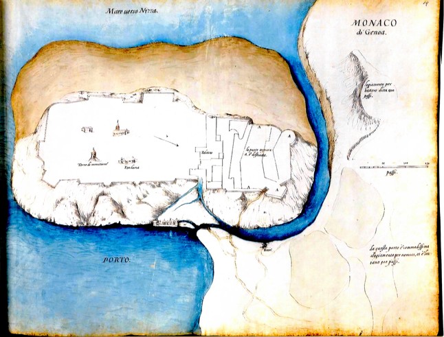
EARLIEST MAP OF MONACO
A 1589-manuscript map of the Principality of Monaco has been discovered in an album in Munich’s Bavarian State Library. The map (below) measures 440x570mm and precedes the earliest map kept in the Palace Archives in Monaco; that map dates from 13 March 1602. The chance discovery was made by Joseph Schirò, Secretary of the Malta Map Society (and a WMS member), who had been looking for early maps of Malta. Joseph immediately contacted Rod Lyon, a specialist in Monaco maps (also a WMS member), who confirmed the importance of the find. This newly-found Monaco map is of special interest for it shows a plan to turn the famous rock of Monaco into an island surrounded by a moat. The map was dates to a time when Monaco was repeatedly under attack from Provence. [Thanks to Rod Lyon for this information.]
Issue 100
Cartographic Notes
Winter 2017
Compiled by Tom Sander
GINSBERG COLLECTION GIFTED TO NORWAY
From a Press Release by the National Library of Norway:
“The world's largest private collection of maps of Norway and the northern areas has been purchased by the Sparebankstiftelsen DNB foundation and [is being] transferred to the National Library of Norway [by the end of 2017]. At the same time, the Government will allocate funds for a new map centre in the National Library. William B. Ginsberg's map collection is the most valuable donation the library has ever received…. “A national cultural treasure is now coming home to Norway,” says Aslak Sira Myhre, director general of the National Library. "When this amazing donation is combined with our existing map collection, the National Library will have the world’s largest and most systematically compiled collection of maps of Norway and the northern regions, which will constitute one of the most important map collections for research in Europe.” ….“This is one of the largest public-private partnerships in Norway ever and the first for a library of this magnitude. We are very happy and grateful to the Sparebankstiftelsen foundation, the Government and William Ginsberg who together have made it all possible,” says Myhre.
About the Ginsberg Collection: American collector (and Washington Map Society member) William B. Ginsberg has spent 30 years building his collection of maps of Norway and the northern regions. The collection consists of atlases and loose map sheets totalling several thousands of maps divided into around a thousand units. The value of the collection is around NOK 60 million [USD 7.7 million]. Among the maps in the collection is the first printed map of the Nordic region from 1482 and the first printed world map on which Norway is drawn from the same year. Ginsberg acquired the maps from all over the world, and has kept the collection primarily in the United States.
CORRECTION TO CORONELLI REVIEW
In the review of Vincenzo Coronelli Cosmopgrapher (1650-1718), The Portolan issue 99, page 62, the town of the publisher Brepols should have read Turnhout, Belgium. We regret the error.
NEW MAP JOURNAL - CALAFIA
California Map Society (CMS) President Susan Caughey has announced a printed copy of the current issue (September 2017) of Calafia, the new journal that has replaced the CMS newsletter. This issue is 28 pages created by its editor Juliet Rothman, publisher Fred DeJarlais and twenty contributors. Although many in the CMS elected to receive the newsletter electronically, the CMS Board of Directors decided that the Calafia is so impressive that members would enjoy a printed copy. It will be issued twice a year and the CMS plans to also mail a printed copy of the next issue to all CMS members. The CMS may then revert to the cost-saving electronic distribution (unless they hear a great outcry for the printed version!).
MORE ON LAMPEDUSA
Portolan issue 99 (Fall 2017), page 87, contained mention of an active Society on that Italian island promoting its history and cartography. Should any readers want to pursue that further, your contact is the group’s President Antonino Taranto, at tarantonino@libero.it .He is especially interested in hearing from anyone who has or has seen an old map of Lampedusa or Linosa. One of their best finds thus far is the map accompanying this article. It was drawn ca. 1775 by the Knights of Malta who were intending to use Lampedusa as a refuge in case of naval battles and bad weather in the Mediterranean. The map was found in the State Archives of Palermo and shows a little inhabited island full of trees. Unfortunately these numerous trees were cut down and used in shipbuilding or to make fires to cook food. Today the inhabitants and the Italian Government are trying to reverse this disaster and have planted trees wherever possible – mostly umbrella pines. The map was drawn ca. 1775 by Domenico Melodia following the observations of Giovanni Battista Ghiott, pilot for the Order of Malta at the time of Grand Master Emanuele De Rohan (1775-1797).
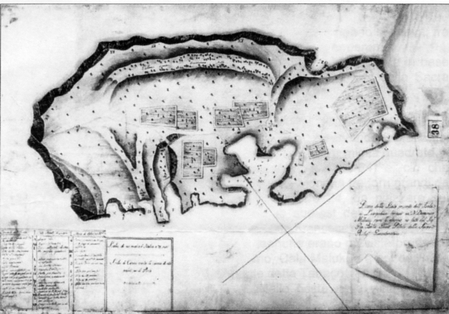
Melodia, Domenico. Map of Lampedusa, ca. 1775.
Issue 99
Cartographic Notes
Fall 2017
Compiled by Tom Sander
VIRGINIA MAPS TO COLONIAL WILLIAMSBURG
From PR Release dtd 19 April 2017: "The Colonial Williamsburg Foundation has acquired one of the finest collections of early Virginia-related maps ever assembled. Through a part gift/part purchase agreement, the Foundation has added more than 220 maps, charts, atlases and documents to its collection, all dating between 1540 and 1835. Collected over four decades by William C. Wooldridge of Suffolk, Virginia, the maps were until recently owned by the Virginia Cartographical Society, a private, Norfolk, Virginia-based consortium. The addition of the Wooldridge Collection gives Colonial Williamsburg the most comprehensive assemblage of Virginia maps outside of the Library of Congress. These objects will be displayed in multiple future exhibitions at the Art Museums of Colonial Williamsburg and will be made available this spring through the Foundation’s online database at www.history.org/museums." Bill Wooldridge is a long-time member of Washington Map Society and the author of "Mapping Virginia: From the Age of Exploration to the Civil War", reviewed in The Portolan Issue 86 (Spring 2013).
VISIT TO MALTA MAP SOCIETY
Your Portolan Editor Tom Sander had the opportunity in June 2017 to spend a week on the very historic islands of Malta and Gozo. If you do not know where that is, Google it. In addition to visiting many fascinating sites, some extending back 7,000 years, he had the opportunity to ‘connect’ with some officers of the Malta Map Society, a relatively new, but very active group of map aficionados. Meetings are frequent, and very scholarly publications are numerous. Readers of The Portolan have seen the many reviews of these books and the Society’s new journal, plus are kept informed of some of the group’s events. A special visit was arranged with the Society’s founder Dr. Albert Ganado at his residence. There were not only numerous maps to be seen (those not yet in the hands of the Government of Malta due to his donation of these unique artifacts), but also his ‘inner sanctum’ where Albert researches often until 2am, learning more about the maps and history of the island group. After this visit, Tom and several Society officers proceeded to the Casino Maltese for continued discussion (over drinks) about map societies and our mutual love of maps. My thanks to Dr. Ganado (President), Ivan Fsadni (VP), Joseph Schirò (Secretary), and Rod Lyon (Press Officer) for their warm hospitality. (They are all WMS members!)
PORTOLAN ARTICLE – NOW IN VIETNAMESE
The Vietnamese journal Review of Danang’s Socio-Economic Development (number 88, April 2017) contains a Vietnamese translation of Hal Meinheit’s article The Bishop’s Map - Vietnamese and Western Cartography Converge that appeared in The Portolan’s issue 97 (Winter 2016). Scholars in Vietnam immediately recognized the excellent scholarship of the article and secured this journal’s permission to translate and reprint it.
PERSUASIVE CARTOGRAPHY
Readers will remember the donation of WMS member PJ Mode’s persuasive cartography collection to Cornell University and his work with Cornell to place the maps online; see The Portolan’s issue 94 (Winter 2015), pages 81-82. Those present will remember PJ’s presentation on this subject to the Society on November 17, 2016. To update readers: Some 500 maps were added to https://persuasivemaps.library.cornell.edu/ as of April 2017, more than doubling the number on line. (If you want to review only the new additions, click on Browse Collection > Browse by Date Posted.) Cornell has implemented a much-improved image browser with a very robust search function. And if you're interested in seeing a slide show of a talk PJ gave on this subject, click on About > Video Presentation.
THE NORTHWEST PASSAGE
The Osher Map Library at the Smith Center for Cartographic Education (University of Southern Maine) recently had a fascinating exhibition called The Northwest Passage: Navigating Old Beliefs and New Realities. As is customary at the Osher, this exhibit and all past exhibits are viewable on the web indefinitely. If you have not seen one of these exceptionally done web exhibits, visit www.oshermaps.org/exhibitions/arctic-exploration to see the current one.
OSHER LIBRARY – MAPS MORE ACCESSIBLE
Digital history company HistoryIT and the Osher Map Library and Smith Center for Cartographic Education (OML) at the University of Southern Maine on April 10, 2017 unveiled a new website www.oshermaps.org/ designed to make the map library’s world-renowned collection accessible to a vast and still-untapped online audience. HistoryIT created cutting edge enhanced metadata for a representative sample of 1,000 of the OML’s more than 1.5 million items. HistoryIT and OML will continue to expand the accessibility of the collection over the next few years, as part of OML’s ongoing digitization efforts.
LATIN AMERICA MAPS ONLINE
For a digitized archive of historical maps of Latin America from 1525 to 1850, see
http://digital.iai.spk-berlin.de/viewer/collections/historische-karten/
'LAFRERI' ATLASES NOW AVAILABLE ONLINE
The National Maritime Museum's two 'Lafreri' atlases have been fully digitized and are now available to view online.
One with 107 maps dated between 1542 and 1565: http://collections.rmg.co.uk/collections/objects/569455.html
One with 67 maps dated between 1546 and 1567: http://collections.rmg.co.uk/collections/objects/1096113.html
NATIONAL LIBRARY OF SCOTLAND
The National Library of Scotland’s July 2017 issue of Cairt: Newsletter of the Scottish Maps Forum is available as a PDF (1.3Mb) at http://www.nls.uk/media/1499580/cairt31.pdf .
The main news items cover new online maps, a new online search interface, recent and forthcoming map publications, two competitions, recent research dating a Pont map, news of a significant recent map collection acquisition, and details of the Library’s new Maps Reading Room. From January to July, an additional 25,000 maps have been put online, taking the Library’s online total to over 194,000 maps.
LEVENTHAL MAP CENTER – MAJOR WEBSITE REDESIGN
In July 2017, the Leventhal Map Center at the Boston Public Library announced the launch of its redesigned website, complete with mobile-friendly digital collections and exhibitions, georeferencing capabilities, and interactive educational tools. Visit www.leventhalmap.org to explore the cartographic materials, including 8,000 maps.
LAMPEDUSA
This Italian island very close to Africa has in recent years been a European destination of many migrants from the Middle East and Africa. In case you visit there and want to talk maps, be aware that this island of only 5,000 has an active society that studies history, maps and cartography; the group even has a website www.archiviostoricolampedusa.it (in Italian only). Lampedusa is the principal one of the Pelagian Archipelago, the others Linosa (500 residents) and Lampione (uninhabited). I am told the food is excellent, the people very kind, and one of its beaches is rated ‘most beautiful’ in the world.
MARY MURPHY CELEBRATES 100
Mary Murphy, a retired librarian, spent her professional life of thirty-six years working in a variety of positions within the Army Map Service and later Army Topographic Command and the Defense Mapping Agency; she was the Editor of the Special Librarians Association (S.L.A.), Geography and Map Division, Bulletin for many years. After her retirement in 1980, Mary became an author and speaker in the field of map librarianship. A past WMS member, she was honored at the 108th Annual Conference of the SLA on June 18, 2017. Several persons spoke on "Mary Murphy at 100 and the Evolution of Map Cataloging,"
PASSING OF MARCIA KANNER
WMS member Marcia Kanner, map enthusiast and co-Founder of the HistoryMiami International Map Fair, died on June 8, 2017 at age 82. For a fine story of her life and contributions, see www.miamiherald.com/news/local/obituaries/article155428019.html .
PASSING OF GUNNAR THOMPSON
Dr. Thompson’s article Newfoundland’s “ ‘Circle Island Group:’ Gateway to Legendary Fortunes in Early North Atlantic Commerce and the Northwest Passage” appeared in this journal’s Winter 2016 issue (#97). Dr. Thompson died on May 7, 2017. He was known for his passionate research into early discoveries primarily in North America. His 2012 book Viking America was reviewed in this journal’s Fall 2013 issue (#87). For more about his life and work, see http://marcopoloinseattle.com/wp/ .
COOK AT 250
The conference COOK AT 250, to be held September 7-9, 2020 in Sydney, will celebrate the 250th anniversary of Cook's discovery of the east coast of Australia with a Historic Cartography meeting that will attract attention across the spectrum of bodies representing interest in the discipline. Primary sponsor Maggie Patton of the State Library of New South Wales has booked the Library’s facilities for September 7-9; the library has an extensive collection of Pacific material. The major exhibition related to Cook will be held over at the Library for the conference. There will likely be a post conference trip to Canberra with a visit to the National Library of Australia’s wonderful collection.
Issue 98
CARTOGRAPIC NOTES
SPRING 2017
Compiled by Tom Sander
CORRECTION TO ROMER ARTICLE
Several errors appeared in the article about Eugeniuz Romer which appeared in issue 96 (Fall 2016) of this journal. (1) Romer would have been 45-46 at the time of publishing not 26. It seems 1891 not 1871 was used as DOB by mistake. (2) Bowman was 41 not 35 (35 was his age for another important leadership role). (3) Lastly, Neil Smith was incorrectly quoted when the article said Smith called Bowman "Wilson's cartographer;” actually Smith called Bowman Wilson's geographer.
AMERIGO VESPUCCI AND MARTIN WALDSEEMÜLLER’S 1507 WORLD MAP
www.museogalileo.it/en/explore/exhibitions/virtualexhibitions/ewaldseemuller.html , A Land Beyond the Stars: Amerigo Vespucci and Martin Waldseemüller’s 1507 World Map, is the website created by the Museo Galileo, in Florence and the Geography and Map Division of the Library of Congress. The website highlights Waldseemüller’s cartography and the science of his times and includes more than eleven hours of interactive video and digital humanities applications surrounding the history of the exploration and navigation of the New World. This amazing interactive website and the early modern science and cartography collections at the Library of Congress. John Hessler, FRGS, Curator, Jay I. Kislak Collection of the Archaeology and History of the Early Americas, Geography and Map Division, Library of Congress, Washington, DC, calls it “digital humanities at its best.”
MALTA MAP SOCIETY JOURNAL – ISSUE 2
The second issue of this journal was published in January 2017. Sent free to members of the MMS, Issue 1 was published in November 2015 and reviewed in the Spring 2016 issue (#95) of The Portolan. This second issue will include the following: A Strange View of Malta by Rod Lyon; The description of an unknown map of Malta by André Thevet extant at the Bibliothéque Nationale in France by Albert Ganado; The de Valette portrait by Matthias Zündt by Joseph Schirò, an unknown Blaeu Mortier state of the Valletta map by Claude Micallef Attard and Joseph Schirò; and From outcrops to maps: the birth of geological maps of the Maltese Islands in the 19th century – Part 1 by Ritienne Gauci and John A. Schembri.
MALTA MAPS – IN THE AIR
The article “Malta’s Exceptional Cartographical History” appeared in the November 2016 edition of Air Malta’s in-flight magazine IL-BIZZILLA. Written by Malta Map Society’s Rod Lyon (also a WMS member), the article notes there are two reasons antique maps of Malta are more numerous and more attractive than those of other Mediterranean islands: the first was the 1530 gifting of the islands to the Knights of St. John. To learn the second reason and to learn more about maps of Malta and the Malta Map Society, read the article in its entirety at https://issuu.com/bizzilla/docs/47_nov_16_web_version/6?ff=true&e=11399628/40122847 on pages 96-97.
PHILIPPINE MAP COLLECTORS SOCIETY
PHIMCOS, conceived in 2007, meets quarterly, always on a Wednesday, and for 2017 the dates have been set as 22 Feb., 24 May, 25 Aug. and 15 Nov. The society has held exhibits, has a website http://www.phimcos.org and also a new journal – The Murillo Bulletin, the three issues of which have been published. If you have an interest in The Philippines and its surrounding region, do go to the website noted to learn more about this active society. If any WMS member should find themselves in Manila on any of those dates, please contact Peter Geldart pcgeldart@gmail.com to join in at the meeting as a guest.
PASSING OF RUTH KANTER
Ruth Kanter, spouse of WMS Charter Member Herschel Kanter, died May 11, 2016. Born April 13, 1928, Ruth was for many years a very frequent attendee at WMS meetings along with her husband. Our condolences to Herschel.
GALVANI RARE MAPS COLLECTION
Mary Pedley, Map Division, William L. Clements Library, The University of Michigan, advises that the Oregon State University has completed the organization and inventory of the Galvani Rare Maps Collection, which comprises more than 1,000 rare maps spanning antiquity to the 20th century, of various regions of the globe. The majority of the maps are not in English. Here are a few links for information about the collection:
http://scarc.library.oregonstate.edu/findingaids/?p=collections/findingaid&id=2110
http://scarc.library.oregonstate.edu/findingaids/?p=digitallibrary/digitalcontent&id=5901
SANBORN MAPS ONLINE In the September/October 2016 issue of the Library of Congress magazine LC, there was an article about the LC effort to digitize their entire collection of Sanborn Fire Insurance maps. According to the article, by year’s end, more than 100,000 maps published before 1900 will be available online. Over the next three years, an additional 400,000 public-domain maps will be added. Link to the Sanborn maps collection: https://www.loc.gov/collections/sanborn-maps/ Thanks to Francis Herbert for pointing out this item.
LONDON’S ENTIRE HISTORY TO BE MAPPED
Layers of London is a huge, multi-partner project with a rather ambitious aim: to map London's history. The British Library, London Metropolitan Archives, Historic England, The National Archives and Museum of London Archaeology are all involved. The plan is to link up all their data on a website and mobile app: then the public can access the info and delve into many different layers of London's history, from the Romans to the present day. The project will in part be funded by the lottery. The people behind the venture, the Institute of Historical Research (part of the University of London's School of Advanced Study) hope the site will act as a hub for new and existing heritage projects across the city. Work started in Barking and Dagenham in May 2016. See http://londonist.com/2016/01/layers-of-london-londons-new-mapping-project .
LIBRARY OF CONGRESS PUTTING MANY MAPS ONLINE
Soon, thousands of maps from the Library of Congress’ collection will be free to gaze at online. Thanks to a new partnership with the Digital Public Library of America, about 5,000 rare and historic maps will soon be easily accessible in a news digital catalogue. Read more: www.smithsonianmag.com/smart-news/library-congress-putting-its-map-collection-on-the-map-180961380/#j6TFXsJZFwYRYxeO.99
CIA CELEBRATING ITS CARTOGRAPHY DIVISION’S 75TH ANNIVERSARY BY SHARING DECLASSIFIED MAPS
Decades of once-secret maps are now freely available online. Read more at: www.smithsonianmag.com/smart-news/cia-celebrating-its-cartography-divisions-75th-anniversary-declassified-maps-180961419/#gOJZX7dVRsvMtruV.99
Issue 97
CARTOGRAPIC NOTES
WINTER 2016
Compiled by Tom Sander
MAKING THE MODERN MAP – LIBRARY OF CONGRESS
The Library of Congress Magazine LCM (www.loc.gov/lcm/) devoted nearly its entire September/October 2016 issue (Vol 5, No 5) to maps, especially treasures from the Library’s own collection. Featured articles range from Mapping the New World, Mapping the Imaginary to Making the Modern Map. A PDF of this entire issue is available for downloading or viewing free at www.loc.gov/lcm/pdf/LCM_2016_0910.pdf .
HAPPY 25TH ANNIVERSARY ROCKY MOUNTAIN MAP SOCIETY
The RMMS (www.rmmaps.org/), based in Denver, this year celebrates its 25th anniversary. A small group of dedicated map enthusiasts has grown the organization to one of the most active in the country, a group that has hosted meetings of the International Map Collectors’ Society and the Society for the History of Discoveries, has teamed with other map societies in holding joint programs, and one that on its own has hosted important national-caliber conferences. From the Washington Map Society (to which many RMMS members belong), congratulations and continued success!
LIBRARY OF VIRGINIA ADDS TWO MAP EXHIBITIONS TO GOOGLE GALLERIES
From the Library of Virginia E-Newsletter of July 2016: “This year the Library of Virginia has posted two map exhibitions in Google Cultural Institute, recently renamed Google Arts & Culture, www.google.com/culturalinstitute/collection/library-of-virginia. An exhibition of select maps and charts from the Alan M. Voorhees Map Collection, Geographia, is divided into four sections that include an introduction and a present-day map that georeferences the area of focus. The sections are titled: 'Early Views of Europe and the World," "Early European Views of America," "British and French Claims of North America," and "Maps of Virginia, Colonial to 19th Century." As viewers visit the Geographia gallery they can read captions about each map and study a particular section by using the built-in zoom features. The exhibition includes short biographies of famous explorers like Ferdinand Magellan and Amerigo Vespucci. An exhibition called Washington complements the Library's 2016 Alan M. and Nathalie P. Voorhees Lecture on the History of Cartography. Held this past April, the lecture focused on the District of Columbia, which at one time included the city of Alexandria. This exhibition explores the evolution of the District through the Civil War as told through manuscript and printed maps and is divided into three sections: "Alexandria in the District," "Washington City in the District," and "The District after 1846." Viewers can research maps of the city and find views of the Capitol, vignettes of the Washington Monument and the Smithsonian, and a printed engraving of the Washington family. Short video clips examine the construction of the Capitol building and the Washington Monument, as well as the life of George Washington.” Text by WMS member Cassandra Britt Farrell, LVA Collections Access and Management Services.
GLOBES AT THE BIBLIOTHÈQUE NATIONALE DE FRANCE
Catherine Hoffman of the BnF reports that 55 globes from the BnF collection have been digitized in 3D. It is the first time so many globes are digitized in volume, and with such details : the precise shape of each object has been scanned, and combined with a high definition texture.
These globes can be accessed on Gallica, the BnF digital library, via dedicated pages. It is possible to navigate the globes
- by theme(terrestrial, celestial, metallic globes),
- by century,
- by geographical origin.
Once you’ve selected the globe you wish to see, clicking the « 3D » button launches the viewer. The digitized item can be rotated in all directions, and zoomed in to discern details not easily seen on the original globe.
The Maps and plans department of the BnF keeps one of the world’s main ancient globes collections : more than 100 terrestrial and celestial globes, dating from the 11th to the 19th century, coming from European or Islamic countries. Among them, unique items from the 16th century, hand-written or etched on metal, exemplify the Great Discoveries era, like Waldseemüller’s 'Green globe', the 1535 'Wooden globe' or the 'Globe of Rouen' (2nd half of the 16th century). The Dutch Golden Age is also present, with globes from Blaeu, Hondius or Van Langren. The 18th century pieces show more numerous globe-makers in France (Delisle, Bion, Delure, Baradelle, Nollet, Robert de Vaugondy, etc.) and across Europe, like Doppelmayr, Senex, Adams.The digitized selection also includes some items of the 19thcentury production (Delamarche, Dien, Thury, Kiepert, etc.) up until a remarkable 1896 Moon globe by Flammarion. See http://gallica.bnf.fr/services/engine/search/sru?operation=searchRetrieve&version=1.2&startRecord=0&maximumRecords=50&page=1&query=%28gallica%20adj%20%22num%C3%A9ris%C3%A9%20en%203D%22%29%20and%20dc.type%20all%20%22carte%22%20sortby%20dc.date%2Fsort.ascending
SYLVIA IOANNOU FOUNDATION, ATHENS
The following books are digitized and published online on www.sylviaioannoufoundation.org (click on Digital Library section) and www.sylviaioannoufoundation.org/digital-library.html (Questions may be sent to Sinfo@sylviaioannoufoundation.org) :
- ca. 1575 [CAMOCIO, GiovanFrancesco (fl. 1552-1575)] - Isole famose…
- ca. 1670 [FRANCO, Giacomo (ca. 1550-1620)] - Viaggio Da Venetia, A Costantinopoli…
-3371 [ROSSI, Giovanni Giacomo de (1627-1691)] - Collection of engraved plates illustrating the wars of the Austrians and the Venetians against the Turks
-1721 AVEYRO, Pantaleam d’ (fl. 1560-1570) - Itinerario Da Terra Santa…
-1572 BALDINI, Vittorio (15..-1618) - Cinque Canti Della Memorabil Guerra…
- ca. 1485 BARTOLOMMEO, dalli Sonetti (fl. 1470-1500) - Al Divo Cinquecento cinque e diece…
-1871 BESANT, Walter (1836-1901), and Edward Henry PALMER (1840-1882) - Jerusalem, The City Of Herod And Saladin...
-1658 BOSCHINI, Marco (1613-1678) - Arcipelago Con tutte le Isole…
-1641 CLUVERIUS [=Cluver, Klüwer], Philipp (1580-1622) - Introductio In Universam Geographiam…
-1756 EPHRAIM, Hierodidaskalos, later Patriarch of Jerusalem, editor (ca. 1713-1771) - Τυπικὴ Διάταξις... τῆς... Μονῆς... Μαχαιράδος…
-1580 FERRETTI, Francesco Annibale (ca. 1523-ca. 1593) - Diporti Notturni…
-1587 FOGLIETTA, Uberto (1518-1581) - De Sacro Foedere In Selimum Libri Quattuor…
-1685 GRAZIANI, Antonio Maria (1537-1611) - Histoire De La Guerre De Chypre…
-1608 HARANT, Kristof (1564-1621) - Putowanj/ aneb Cesta z Kralowstwj Cžeského do Města Benátek…
- ca. 1790 MOLL, Herman (?1654-1732) - Geographia Classica…
-1568 NICOLAY, Nicolas de (1517-1583) - Navigations Et Peregrinations Orientales…
-1827 PARUTA, Paolo (1540-1598) - Storia Della Guerra Di Cipro…
-1482 PTOLEMAEUS, Claudius (fl. 2nd c. A.D.) - Cosmographia…
-1535 PTOLEMAEUS, Claudius (fl. 2nd c. A.D.), and Michael SERVETUS, editor (1511-1553) - Geographicae Enarrationis Libri Octo...
-1605 PTOLEMAEUS, Claudius (fl. 2nd c. A.D.), and Petrus MONTANUS, editor (1560-1625) - Geographiae Libri Octo…
- ca. 1670 SELLER, John (1632-1697) - Scripture Geography…
- ca. 1828 STACKELBERG, Otto Magnus von (1787-1837) - Costumes & Usages des Peuples de la Grèce Moderne…
-1554 THEVET, André (1502/1516-1590) - Cosmographie De Levant...
Visit www.sylviaioannoufoundation.org/digital-library.html
Issue 96
CARTOGRAPIC NOTES
FALL 2016
Compiled by Tom Sander
REMEMBERING CAROL WELCH
A full life ended too soon with the passing of WMS member Carol Welch (Dec 14, 1944 – March 17, 2016). For Carol, and surviving husband Cal, map collecting was a grand opportunity to explore the world and rendezvous with friends. Equally rich was life at home. Carol was an involved leader with the First Reformed Church and a range of civic endeavors in her birthplace, Schenectady, NY. An active outdoorswoman, she skied, boated, and raised champion hunting dogs. She carried a professional career to retirement as a special education teacher. All this while raising two children, Caroline and Christopher (Erica). Fittingly, her favorite map was the Leo Belgicus, rising to meet the world. Even in death she made an impact, donating her body to Albany Medical College.
CORRECTION - TONY NICHOLLS
The author deeply regrets incorrectly reporting the name of the provider of information for the article, “GPS 1.0 beta, AKA Britannia Depicta…(or, Travel Commentary in Strip Maps)” on pages 46-40 of Portolan issue 85 (Winter 2012). The source’s correct name (page 49, column 2, third paragraph) should have been Tony Nicholls, www.pastpages.co.uk/ .
A HISTORY OF THE MAP TRADE – one dealer’s view
As Jonathan Potter, a WMS member and map dealer said : This is a personal view of what continues to be a very fulfilling and enjoyable career – I have been paid to do a hobby. Some might say this is self-indulgent, not much good for anyone except those who like out-of-date, possibly expensive, perhaps interesting pieces of paper, but if you work with maps, study or collect them, you appreciate their significance as vivid, often attractive, records of the past and as documents that merit attention. For "A Map Dealer's Reflections on the Last Forty Five Years," see www.jpmaps.co.uk/WarburgInstituteTalk
THE MAPS OF A. J. JOHNSON – AN UPDATE
Readers of this journal will remember the three articles by Ira Lourie that have appeared on the maps of mapmaker Alvin J. Johnson: in issues 49, 83 and 91. The U.S. Johnson Map Project (JMP) has updated its website database of the maps of the United States found in Johnson’s Family Atlases from 1860-87. This includes both 1) the additions of newly discovered variations of the 67 U.S. maps and 2) the updating of the “Rarity Index” data based on a second year of monitoring the availability on E-bay and on map dealer websites of the each of the over 650 variations of the 67 U.S. maps. Over the last year the JMP cataloged over 500 additional maps newly offered on E-bay. Following from the cataloging of these new maps, there have been 6 new map variations discovered and 69 map variations have had their Rarity Index status changed. This data is now available at the JMP website: JohnsonMapProject.org . Details of the newly discovered variations and specific changes in rarity data can be obtained by sending an email request to Maps@JohnsonMapProject.org.
DISTRICT OF COLUMBIA MAPS AT ONLINE PORTAL
Lauren Martino, Map Librarian, District of Columbia Public Library, Special Collections reports the addition of some new maps to Dig DC, the online portal to DC Public Library Special Collections. The maps are being rolled out in sets of about 50 maps. This first set covers 1768 to the Civil War. See http://dclibrary.org/node/51804 ; contact lauren.martino@dc.gov
DAVID RUMSEY MAP CENTER
The David Rumsey Map Center, part of the Stanford University Libraries, opened on April 19, 2016. Stanford University Libraries is pleased to announce the opening of the David Rumsey Map Center on April 19, 2016. The David Rumsey Map Center is a unique collections-based resource designed to provide access to cartographic information in all of its forms from paper to digital. In addition to housing a large collection of rare atlases and maps, it is furnished with high-resolution screens equipped with interactive tools for engaging with the digital images. The Center is supported by knowledgeable staff and is a flexible and rich environment for research and teaching. The Rumsey Map Center, named for its leading donors, David and Abby Rumsey, complements the long history of working with cartographic materials in the Stanford Libraries. It combines the David Rumsey Map Collection of some 150,000 maps and their digital surrogates with other cartographic collections and materials held at Stanford, including the Oscar I. Norwich Collection of African Maps, and the Glen McLaughlin Collection of California as an Island Maps. And by adding a rich suite of digital tools to the physical maps, the Center offers a whole that is much greater than its parts. It promises to spark new ways to display, encourage, enable, and disseminate research.
NYPL – DIGITAL COLLECTIONS – MAPS & ATLASES
More than 180,000 items in the Digital Collections of the New York Public Library are in the public domain. That means everyone has the freedom to enjoy and reuse these materials in almost limitless ways. The NYPL now makes it possible to download such items in the highest resolution available directly from http://digitalcollections.nypl.org/ . For those of us who love maps, go to http://digitalcollections.nypl.org/collections/lane/maps-atlases and http://digitalcollections.nypl.org/divisions/lionel-pincus-and-princess-firyal-map-division .
18TH-CENTURY MAPS OF CENTRAL EUROPE
The University of Chicago Map Collection has put up a new page of scanned maps, this one focusing on 18th-century maps of Central Europe. The URL is www.lib.uchicago.edu/e/su/maps/centraleurope18 . The page differs from other Map Collection compilations of scanned maps in that it provides access to a great deal more material; the maps are all older than those on the other pages; and the links for the moment are only to Luna (rather than to Zoomify and Luna). In summer 2015 the Luna access was added to all the previously created pages, listed at www.lib.uchicago.edu/e/collections/maps/index.html#SCANS . Read about this at www.lib.uchicago.edu/e/su/maps/news.html
NEW MMS PROJECTS FOR 2016/17 The Malta Map Society (MMS) has announced two new projects for 2016/17. Firstly, the translation and publication of the only known Russian book and folding map devoted entirely to Malta and its islands. This extremely rare book (5 copies are known) was published in St. Petersburg in 1800 by Gregory Krayevsky who had visited Malta in 1785 as a translator in the expedition of Count Paul Martinovich Skavronsky(1757-1793), the Russian Ambassador to Naples. Secondly, the MMS has begun work on the compilation of a detailed study of the many French maps of the Maltese Islands.
Issue 95
CARTOGRAPHIC NOTES
SPRING 2016
Compiled by Tom Sander
CORRECTION TO ISSUE 94
On page 1, Inside, the correct name of the reviewer of Der Erdglobus des Johannes Schöner von 1515 should have read: Suzanne Karr Schmidt.
PERSUASIVE CARTOGRAPHY – UPDATE
Readers of this column in this Winter 2015 issue (#94), pages 81-82, will remember the story of PJ Mode’s donation of maps depicting persuasive cartography to Cornell University. Cornell has installed new software that notably improves the usability of the Persuasive Cartography website at https://persuasivemaps.library.cornell.edu/ . It is now much easier to do searches, to view the maps in high definition along with the associated Notes, and to download or print material of interest. To see this, go to Persuasive Cartography and click on Browse Collection. The software upgrade supports tablets and smartphones, but the collection is still best accessed on a desktop or laptop if possible. PJ is still working on plans to add another 400 or so maps.
PEUTINGER TABLE MAP ONLINE
The Peutinger Table map is online at http://peutinger.atlantides.org/map-a/ with editable overlay layers and variable opacity for map and layers. A great way to analyze features on the map.
HISTORIC TOWNS TRUST – UK - OXFORD
“The Historical Map of Oxford” has been produced as part of the British Historic Towns Atlas of Oxford. The atlas will form vol. VII of the successful series of atlases of historic British towns and is in preparation. With expected publication date in 2017, the Oxford Atlas project seeks financial support to keep production deadlines; for information, see www.historictownsatlas.org.uk/content/oxford-atlas-project . The individual map released in January 2016 has an introduction, gazetteer of Oxford’s historic buildings and sites, and illustrations. Appears to be a good value at UK£ 8.99; see www.historictownsatlas.org.uk/content/map-historic-oxford .
MINI-LECTURES ON MAP COLLECTING
WMS members and map dealers George and Mary Ritzlin have updated the LEARN section of their website with ten videos of mini-lectures on map collecting, how maps were made, and much more. The videos can also be seen on YouTube. See www.ritzlin.com/learn.html
QS WORLD UNIVERSITIES RATINGS
The QS World Universities 2015/2016 list just came out. www.topuniversities.com/qs-world-university-rankings has the list of the Top 100 worldwide. By Bert Johnson’s count, fifteen of those august institutions have one thing in common - they are Portolan subscribers.
WMS MEMBER DIANE SCHUG-O’NEILL IN THE NEWS
The January/February 2016 issue of LCM – Library of Congress Magazine included a full page devoted to the Scanning Lab in the Geography and Map Division of the Library of Congress. A photo at the page shows Diane Schug-O’Neill digitizing a map from the collections. Many of these maps later appear on the LC’s website, made available worldwide online. See www.loc.gov/lcm/pdf/LCM_2016_0102.pdf
WMS MEMBER RON GRIM IN THE NEWS
The Samuel de Champlain map Carte Geographique de la Nouvelle France…faict en 1612 was identified by Ron Grim, Curator at the Norman B. Leventhal Map Center at the Boston Public Library, in an antiques publication in summer 2015. Missing for over ten years, this map had prominent tear marks that corresponded with photographic records held at the Library. An independent third party expert confirmed the findings. The map has been returned and is now on display in the Leventhal Map Center. See www.bostonglobe.com/metro/2015/12/04/stolen-rare-map-returned-boston-public-library/B5kgP1M8yi0fdWwxT0fY2K/story.html and www.cityofboston.gov/news/default.aspx?id=20454\
CAPE HORN – 400th ANNIVERSARY OF ITS DISCOVERY
Bert Johnson, on the WMS Facebook site, recently reported about WMS member Hans Kok delivering a map and globe-filled video presentation about Cape Horn. Magellan was Portuguese but the Dutch won the name game by calling it after the Dutch city of the same name. The film, in Dutch, is at https://vimeo.com/151876342?ref=fb-share .
HIGH-RESOLUTION IMAGES OF THE LENOX GLOBE (c. 1510)
Readers of this journal will remember Dr. Stefaan Missinne’s article in Issue 87 (Fall 2013) – “A Newly Discovered Early Sixteenth-Century Globe Engraved on an Ostrich Egg: The Earliest Surviving Globe Showing the New World.” His research generated many subsequent articles in The Portolan by commentators and scholars, and comparisons were made to the Hunt-Lenox Globe at the New York Public Library, The below interesting development was announced by Chet Van Duzer, a member of the Lazarus Project at the University of Mississippi. “In January of 2015 together with my colleagues Gregory Heyworth of the University of Mississippi, and Ken Boydston of MegaVision, I participated in a project to image the Hunt-Lenox Globe of c. 1510 at the New York Public Library. The three of us are members of the Lazarus Project, which brings advanced imaging to cultural institutions all over the world www.lazarusprojectimaging.com/ . The imaging of the globe was generously funded by the Samuel H. Kress Foundation, and was coordinated at the NYPL by Matt Knutzen, then Geospatial Librarian, and Michael Inman, Curator of Rare Books, to which division the globe belongs. The ultimate goal of the project is the generation of a very accurate and high-resolution 3D digital model of the globe, which will permit users to rotate and zoom in on the digital facsimile however he or she chooses, to study even the smallest detail. The 3D model, which will soon be released by the NYPL, was created by David Kelbe (Rochester Institute of Technology) using a mathematical technique called Structure from Motion. In the meantime, the NYPL has released high-resolution 2D images of the northern and southern hemispheres of the globe projected onto a plane, which we generated as part of this project. Here are the links:
Northern hemisphere:
http://digitalcollections.nypl.org/items/16891d60-66fc-0133-fbd6-00505686a51c
Southern hemisphere:
http://digitalcollections.nypl.org/items/f7a0eb50-66fb-0133-9c56-00505686a51c
On both of these pages one can zoom in on the globe to a certain extent, but by clicking on “Original” in the “Download Options,” one can access – for free – a 300 MB jpg of each hemisphere, and by clicking on “All Download Options” and then “High Res (TIF format)” one can access a very high-resolution TIF image of each hemisphere (the TIF files are very large). With these images one can examine the globe in great detail. In the past, the globe’s status as one of the NYPL’s treasures has meant that access to it was restricted, and the available images of the globe were less than satisfactory. It was a pleasure working with the NYPL on this project, and we hope that these images will help scholars address current questions about the globe, and also inspire new ones.”
HISTORY OF CARTOGRAPHY – CELEBRATED BY NEH
For its 50th anniversary, the National Endowment to the Humanities (NEH) is highlighting select projects they have supported that “have enriched and shaped American lives.’ The History of Cartography Project at the University of Wisconsin has been honored to be included in this prestigious group. Grants totaling $5,178,782 from NEH have provided invaluable backing for four volumes of its epochal reference compendium - The History of Cartography. Many private and organizational donors have given private gifts which in turn release NEH matching funds. See more at: http://50.neh.gov/projects/history-of-cartography#sthash.GcaVPi1e.dpuf
MAP BLOG – LIRARY OF CONGRESS
Did you know that the Geography and Map Division of the Library of Congress has an active blog about maps? Titled “Worlds Revealed: Geography & Maps at the Library of Congress”, and found at http://blogs.loc.gov/maps/ , its goal is to reveal the world of geography by exploring the past, present, and future of maps and mapping.
UPPDATE TO THE MAPPING OF NORTH AMERICA
Many readers will be familiar with or own one or both volumes of Philip Burden’s ‘The Mapping of North America’. Revisions and additions are frequently posted to a website so the books (1996 & 2007) are constantly up-to-date. The latest updated version of the Addenda for both volumes of ‘The Mapping of North America’ is now online and free to download. This makes the latest information from the last two years available. It can be found at www.caburden.com/index.php.
Issue 94
CARTOGRAPHIC NOTES
WINTER 2015
Compiled by Tom Sander
PERSUASIVE CARTOGRAPHY
WMS member P.J. Mode has been working with Cornell University for some time to put up a web site for his collection of "persuasive cartography." You know, such as comic maps with political allegory. Part of the collection is now at http://persuasivemaps.library.cornell.edu/ . The web site offers background and information about persuasive cartography in general and links to some 300 maps, with high-resolution images and descriptive notes for each map. One of the maps is at page 82 of the Winter 2015 issue of The Portolan. The maps can be browsed easily by subject or date range or searched by key word. P.J. continues to work with Cornell, and a future addition of another 200-400 maps is in the works.
A few words of explanation:
- The site uses an image browser called Artstor Shared Shelf. If you haven't used it before, look at the brief "Image Browser Tips" (under "Browse Collection") before you start to browse. P.J. recommends beginning by using "Browse By Subject."
- The best way to view a single map on Shared Shelf is to double click on the thumbnail; it will enlarge to fill the window. Then click on the information icon "i" below the map; this will display a slightly smaller copy of the map with the Collector's Notes and all descriptive data below it. Other icons allow you to enlarge the image, print, or download a copy.
- For use of the web site on mobile devices, see the explanation under Image Browser Tips.
P.J. welcomes suggestions, feedback and corrections to both the web site content and the descriptions accompanying the images, particularly his Collector's Notes. Contact him at pj@pjmode.com
ICHC ABSTRACTS
For those not able to attend ICHC Antwerp, the abstracts of the papers are at the following link: www.felixarchief.be/Docs/Stad/Bedrijven/Zelfstandige_stadsdiensten/FEA/2015/Programmaboek_los.pdf .
Issue 93
CARTOGRAPIC NOTES
FALL 2015
Compiled by Tom Sander
VOLUME 6, CARTOGRAPHY IN THE TWENTIETH CENTURY
The latest volume (actually a boxed set) in the History of Cartography series was released in April 2015. It has 1,960 pages, 805 color plates, 119 halftones, 242 line drawings, 61 tables. ISBN 978-0-226-534695. The volume includes more than five hundred articles accompanied by more than a thousand images. Hundreds of expert contributors provide both original research, often based on their own participation in the developments they describe, and interpretations of larger trends in cartography. The volume was designed for use by both scholars and the general public.
PAINT OVER PRINT: HAND-COLORED BOOKS AND MAPS OF THE EARLY MODERN PERIOD
Jay Lester reports that the presentations at this February 2015 conference held in Philadelphia are now available for viewing online. Two lectures have penn.edu URLs; these two lectures are best viewed with Internet Explorer on a PC, and on Apple IOS.
Opening Remarks by Lynne Farrington, Larry Tise, and Chet Van Duzer
https://www.youtube.com/watch?v=az4voKZ3UcE
David Bosse, Historic Deerfield
“‘To Give a Strong and Pleasing Effect’: Hand-Coloring in Historical Context”
https://www.youtube.com/watch?v=3Ussih-OJ4Y
Chet Van Duzer, Independent Scholar
“Colored as its Creators Intended:
Painted Maps in the 1513 Edition of Ptolemy’s Geography”
https://www.youtube.com/watch?v=pq0M5WPX3Do
William C. Wooldridge, Suffolk, Virginia,
author of Mapping Virginia (UVA Press, 2012)
“Collecting Color−A View from the Trenches”
https://www.youtube.com/watch?v=4W3yiQUgiuY
Stephanie Stillo, Washington and Lee University
“Authenticity and Authorship in Early Modern Colored Maps”
https://www.youtube.com/watch?v=lb0KWw4KIcg
Michiel van Groesen, University of Amsterdam
“‘An Ocean of Rumors’: News from the Atlantic World”
https://media.sas.upenn.edu/app/public/watch.php?file_id=186525
Graham Arader, Arader Galleries, New York, NY
“Detecting Fakes and Forgeries in the Market for Hand-Colored
Books, Maps, and Prints”
https://media.sas.upenn.edu/app/public/watch.php?file_id=186526
Michiel van Groesen, University of Amsterdam
“Theodor de Bry and Sons, Master Engravers and Printers
for the Hand-Colored Book Market”
https://www.youtube.com/watch?v=WkaIeE93UBM
Larry Tise, East Carolina University
“America’s First ‘Coloring Book’: Theodor de Bry’s 1590 edition of
Thomas Harriot’s Briefe & True Report from the New-Found Land of Virginia”
https://www.youtube.com/watch?v=QXQqQp6CwTg
Joan Irving, Paper Conservator, Winterthur Museum, Garden, and Library,
Wilmington, Delaware
“‘Not Just for Ornament’: Transparent Liquid Colors for Maps & Plans”
https://www.youtube.com/watch?v=pjelO0i0nt0
Peter Stallybrass, University of Pennsylvania
“Hand-Colored Herbals”
https://www.youtube.com/watch?v=r4DqImNj6js
Speakers’ Roundtable
https://www.youtube.com/watch?v=X5kj4Sx_TM4
MALTA MAP SOCIETY
The MMS held its Annual General Meeting on February 28, 2015. The Society plans to publish a “Glossary of Cartographical Terms” and a hardbound scholarly study of the pre-siege (before 1565) maps of Malta. Michael Ritter, a German collector who specialises in eighteenth-century German cartographers who worked in Augsburg, met with the MMS Secretary and provided much new information about certain entries in the German Malta Map catalogue; he also provided a high resolution image of a 1798 Malta map by Johann Michael Probst, formerly unknown. Those interested in the maps of Malta are encouraged to join, for the Society produces robust newsletters with scholarly studies of past mapping of the island. See http://maltamapsociety.com .
NEW YORK MAP SOCIETY
The NEW URL for the New York Map Society is www.newyorkmapsociety.org
ATLASES ONLINE
A newly released website www.rare-atlases.com presents eleven pre-1800 atlases; more atlases are expected to be added in the future. All maps are zoomable. The host of the website is a dealer, the images are wonderful.
TWELVE MAPS
“Better than GPS: a history of cartography in 12 amazing maps” is the title of an article in England’s GUARDIAN newspaper. It looks back a 12 often familiar maps of the past in an enjoyable article. See www.theguardian.com/commentisfree/2015/may/04/gps-history-of-cartography-amazing-maps?CMP=share_btn_link
MAPPING MALARIA
On April 24, 2015 PBS Newshour in the USA aired a segment on high-tech mapping techniques that have been developed to help fight malaria: www.pbs.org/newshour/videos/#142095 . There is also a link to a transcript of the video. From that transcript: "[University of California at San Francisco Professor] Sturrock’s maps rely on data, much of it photos, that have been, and still are, collected by NASA satellites circling the globe. But that information, 40 years’ worth, has languished in government vaults in South Dakota. Now Google Earth Engine has acquired it, for free, and is working with the university and many others to put it to work. For several years, Google has been storing data, trillions of measurements, on thousands of computers that it owns. But, until recently, and, in fact, even now, using that data, making sense of it has been very difficult. Sturrock, with the power of thousands of Google’s computers at his fingertips, is combining the satellite pictures with on-the-ground information, using algorithms. ..." Thanks to Joel Kovarsky for this note.
EARTHWORKS: STANFORD'S NEW GIS DATA DISCOVERY APPLICATION
Stanford University Libraries has introduced EarthWorks[https://earthworks.stanford.edu], its new geospatial data discovery application. EarthWorks allows you to discover and download GIS data and maps from a variety of institutions. The software is built on top of the open-source project GeoBlacklight [http://geoblacklight.org], which adds geospatial capabilities to the widely used discovery system Project Blacklight [http://projectblacklight.org/]. GeoBlacklight is the product of an ongoing software collaboration between MIT, Princeton, and Stanford. Contributions and collaborators are most welcome! https://github.com/geoblacklight/geoblacklight/wiki/Contributing GeoBlacklight can be used on its own, or as part of GeoHydra, an emerging suite of tools for managing geospatial data assets within a Hydra data repository. For more information about GeoHydra, please see the interest group wiki https://wiki.duraspace.org/display/hydra/Hydra+Geospatial+Interest+Group .
Metadata sharing for EarthWorks is enabled through collaboration with the OpenGeoPortal project [http://opengeoportal.org/] and the new OpenGeoMetadata initiative [https://github.com/OpenGeoMetadata/metadatarepository]. EarthWorks also uses GeoMonitor [https://geomonitor.stanford.edu/] to monitor the availability of data being provided by the network of collaborating institutions. Questions about EarthWorks, GeoBlacklight, GeoMonitor, or how it collaborates with OpenGeoMetadata can be directed to geoblacklight-working-group@googlegroups.com .
NUREMBERG CHRONICLE
I thought that this particular post might interest some here, particularly given the focus of the last entry on Anton Koberger: http://www.bpl.org/distinction/2015/03/17/anton-koberger-at-the-bpl/ . They also provide a link to that fully digitized German version of the Nuremberg Chronicle: https://archive.org/details/buchdercronikenv00sche .
http://www.bpl.org/distinction/ Thanks to Joel Kovarsky for this note.
Also
Although not the entire book, some ten years ago I produced an original technology new edition of the famous Nuremberg Chronicle's world map in my private workshop. The identification of that woodcut is more than easy for anyone who could see Schedel's work: it is my edition if the big foot guy (a Sciapod) appears in the panel of the monstrous races. Actually, all the creatures along the left margin of my world map were taken from the verso of the 1493 edition. As a special treat, instead of monsters, I printed the new edition of the world map from Schönsperger's pirated miniature edition (1496) on the verso of my large woodcut. As now we have quite a few digital reproductions available online it is no longer a problem to have a look at the 1493 edition of the world map - and occasionally make a comparison. This note is from Dr. Zsolt Török, Cartart Workshop.
MAP MANNA
Here is a make-your-day story - stay with the video to at least 6 minutes and 30 seconds in to see the video's real visual treasures and the comment much later on the "power of maps" . . .
I think you will be joyfully surprised.
http://la.curbed.com/archives/2015/03/los_angeles_maps_lapl_john_feathers.php
Best wishes,
Don.
Donald C. Dahmann, Ph.D.
Geographer in Independent Practice
Issue 92
CARTOGRAPIC NOTES
SPRING 2015
Compiled by Tom Sander
NOW - THE GEOGRAPHY AND MAP DIVISION RESEARCH CENTER
Readers of The Portolan Issue 91 (Winter 2014) will remember the article about the recent renovation of the Geography and Map Division of the Library of Congress. Shortly after that issue was mailed, Division Chief Ralph Ehrenberg announced that Reading Room will now be called the Geography and Map Division Research Center, explaining “This is not simply a change in name; rather the new title reflects greater purpose and increased utility for the room. For the first time, we have dedicated space for research, lectures, GIS, and rarities. Overall, it serves to enhance our operations, as well as the experience of researchers and visitors.”
MALTA MAP SOCIETY – FIFTH ANNIVERSARY
January 2015 marked the fifth anniversary of the MMS, and the WMS wishes them many more productive years. To learn more of this island and the MMS, visit www.maltamapsociety.com
MALTA - LAST PROFESSIONAL COPPER ENGRAVER
On November 26, 2014, members and friends of the Malta Map Society met in Valletta for a film and talk on the subject of copper engraving for maps. The film presented the work of the last professional copper engraver in Germany ...Rainer Kalnbach... who was working in Hamburg on sea charts until 1960, having engraved on copper from the age of 14. After the film Jesmond Vassallo, a young Maltese artist and engraver, showed and discussed the various printing methods used and presented examples of engraving equipment. Thanks to David Roderick Lyon for this report.
LOST A MAP LATELY?
Art Loss Register in London claims to hold the largest private database of stolen and missing art, antiques and collectibles worldwide, with over 420,000 items registered. They search auction house catalogues and private sales worldwide in order to check for stolen goods. Items registered on their database remain listed until they are recovered, which may be any number of years later. When they identify a stolen or missing object, they contact the registrant immediately and assist in returning the property to its rightful owner or finding a settlement with the current holder. Info at www.artloss.com/register/loss . (This is for info only and does not imply endorsement by the WMS.)
Issue 91
CARTOGRAPIC NOTES
WINTER 2014
Compiled by Tom Sander
THIS PAGE IS AT THE WMS WEBSITE FOR EASY ‘LINKING’
By popular request, this page and similar one back to the Spring 2013 issue, are now posted to the WMS website for easy linking to the websites cited below. Go to www.washmapsociety.org/CN.htm .
PAUL PEAK (1923-2014)
Paul Peak, retired U.S. Coast Guard Officer, died October 19, 2014 with his wife of 70 years, Jane, at his side. He served 33 years in the Coast Guard including participation in World War II; he also served at the national level in The Retired Officers Association, the U.S. Coast Guard Auxiliary, the Clan Ross Foundation, and Palatines to America. An active Washington Map Society member and supporter since 1990, Paul’s interests were “genealogical; 17, 18, & 19 c. Germany & British Isles; 17 & 18 c. N England & Mid-Atlantic states; 19 c. Midwest / auction sales of maps; charting coastal waters.”
WASHINGTON MAP SOCIETY MEMBERSHIP DIRECTORIES The Washington Map Society has moved to the digital age and since 2012 has not published a print edition of the membership directory. A frequently updated membership directory is available online in the members-only section of the Society’s website at www.washmapsociety.org/ . If you have not yet registered for the members-only section of the website, see www.washmapsociety.org/WMS-Members-Only-Section.htm for instructions about how to register. Registered members of the website can consult the current membership directory at www.washmapsociety.org/Membership-Directory.htm . Please contact Leigh Lockwood at www.washmapsociety.org/Contact_Us.htm for questions about registering for the members-only section of the website. Please notify John Docktor at washmap@gmail.com if corrections or changes are need in your listing in the membership directory.
CORRECTION TO BOOK REVIEW – Food: an Atlas
In The Portolan Issue 90 (Fall 2014), in the third paragraph on page 66, there are two misspelled words in one name: Joshua Jolly-Shapira should be Joshua Jelly-Schapiro.
MARTELLUS AND WALDSEEMÜLLER Ray Wolf has alerted us to an article from Wired about Chet Van Duzer’s work relating the 1491 Martellus map at Yale to the Waldseemüller 1507 map at the Library of Congress. See www.wired.com/2014/09/martellus-map/
ONLINE DIGITAL MAP COLLECTIONS
Many online digital map collections are now searchable and accessible through the OldMapsOnline portal http://project.oldmapsonline.org/collectvions . These include two collections at the British Library Map Library, the David Rumsey Collection, the Charles University in Prague, the Dutch National Archives, the Harvard Library Map Collection, the National Library of Scotland, the National Library of Wales, the New York Public Library, and several more. Nearly all the institutions providing online map collections have a much larger paper map collection available at their respective institutions, but the OldMapsOnline portal will only search and provide direct linkage to the online maps.
ART GALLERY OPENING
WMS member Michael Reagan is an accomplished artist of over 35 years’ experience who specializes in artistic portrayal of maps. His clients include dozens of America’s top magazines (e.g., National Geographic, Smithsonian) and publishers (e.g. McGraw/Hill, Little/Brown). On 3 October 2014, a month-long show of his work opened at Gallery A, 2601 R Street, NW, Washington DC. His works can be seen on his Profile on the WMS web site and on his personal web site (www.mapsbymikereagan.com). Thanks to Bert Johnson for providing this summary.
TRICKS AND TIPS FOR FINDING AND USING USGS TOPOGRAPHIC MAPS
THE US NATIONAL MAP SMALL-SCALE COLLECTION
The US Geological Survey has advised that The National Atlas (www.nationalatlas.gov) has been removed from service. See that site for more information.
MALTA MAP SOCIETY – MAPS OF MALTA
Have you noted that the WMS has been paying a lot of attention to a small island in the Mediterranean Sea – MALTA? The reason is that a very dedicated group of map scholars there formed the Malta Map Society (MMS) and started a newsletter with excellent research content. Further, several of the scholars have been writing prolifically about maps of Malta. These books have been reviewed in this journal and have gotten much praise. Our late president Howard Lange served in Malta in the US Foreign Service and saw the beginning of this work; he would be very proud of the work being does to research and present the maps of Malta to the world. If you have any interest at all in this fascinating island, please visit www.maltamapsociety.com
HISTORIC MEETING OF TWO FAMOUS MAP COLLECTORS
On 19 September 2014 two world-famous antique map collectors met at the National Museum of Fine Arts in Valletta, Malta’s capital. They were 90-year-old Dr. Albert Ganado, whose Malta map collection was exchanged with the Malta Government for his 1571 house, and 80-year-old Glen McLaughlin, whose collection of “California as an Island Maps” was recently part sold/part donated to Stanford University, California for the benefit of the general public. Both collectors took over 50 years to form their collections.
During the visit, Ganado showed McLaughlin several siege maps of Malta and explained the various states and editions which were published in connection with the Great Siege of Malta of 1565. They narrated several episodes and anecdotes on how they had acquired certain maps in their prospective collections. Then McLaughlin was shown a map of America by Jean de Beauvais published in Paris in 1788 and it was his turn to fill all those who attended the meeting with his wisdom on America in general and California in particular, and how it was the Jesuit Rev. Eusebio Kino who finally ended the myth of California as an island.
Issue 90
CARTOGRAPIC NOTES
Fall 2014
Compiled by Tom Sander
FAREWELL MAPHIST; WELCOME ISHMap-List Back in the old days, questions or announcements related to any aspect of cartographic history were easily broadcast far and wide via the MapHist listserv. A few years ago, MapHist migrated away from an email listserv to an on line forum. Although well designed, the forum has failed to maintain the passion and level of discussion that existed previously in MapHist’s listserv format. An announcement was made on 19 June 2014 that the MapHist Forum will be closed and web site removed by January 2015. In an effort to recapture those qualities, the International Society for the History of the Map recently created the ISHMap-List, an email listserv open to anyone interested in cartographic history. You can sign up for this email discussion group at no charge via this web site: http://lazarus.elte.hu/cgi-bin/mailman/listinfo/ishm. Although membership in ISHM is not required to subscribe to ISHMap-List, you are welcome to join ISHM at http://ishm.elte.hu/?q=node/84 .
MAP HISTORY DIRECTORY (OF RESEARCHERS) This directory is an open source for contact information, current interests, research projects and publications related to map history. The Map History Directory was created, and is hosted by, the Osher Map Library and Smith Center for Cartographic Education at the University of Southern Maine on behalf of Imago Mundi Ltd. This Directory is, in effect, the tenth edition (known informally as “D10”) of a series of published directories of research contacts in the history of cartography; D9 was printed in 1998. The ‘information age’ and digital world makes print editions virtually outdated before they are printed, thus the current Directory is digital and available online to anyone to consult. In the directory are listed names of researchers and authorities in the history of cartography. The list is constantly increasing. Consult the list, and consider adding your name. See www.maphistorydirectory.org/index.php/The_International_Directory_of_Researchers_in_Map_History .
1000 YEARS OF CHANGING BORDERS
http://loiter.co/v/watch-as-1000years-of-european-boarders-change/
HEREFORD MAPPA MUNDI
The newly-unveiled Hereford Mappa Mundi website is at www.themappamundi.co.uk . As well as instruction for the unversed, it contains a fascinating array of different ways of viewing the map, even for those who think they know it inside out.
THE EARLIEST MAPS OF MALTA FROM PTOLEMY TO THE GREAT SIEGE OF 1565
Joseph Schiro, Secretary of the Malta Map Society, has announced that the exhibition and hardback volume on this subject is now planned for October 2014. The project is based on the groundbreaking research carried out – and still ongoing – by Dr. Albert Ganado, who is President of the Malta Map Society and this year celebrated his 90th birthday.
THE MAGELLAN MYTH – 3RD EDITION
A new third edition of The Magellan Myth: Reflections on Columbus, Vespucci & the Waldseemueller Map of 1507 is now available. With WMS permission, the author, Peter Dickson, has included in this edition his essay “A Commentary on the Twin Lenox and Ostrich Egg Globes” that was published in the Spring 2014 issue of The Portolan. It is available at Library Shop at the Library of Congress (http://loc.gov/shop), or from the author – contact pwdbard@aol.com .
THOUSANDS OF HISTORIC MAPS RELEASED BY NEW YORK PUBLIC LIBRARY
The Lionel Pincus & Princess Firyal Map Division has released more than 20,000 cartographic works as high resolution downloads under a cc0 (Universal Public Domain Dedication) via maps.nypl.org . Read more www.nypl.org/blog/2014/03/28/open-access-maps and www.historytoday.com/blog/2014/04/thousands-historic-maps-released-new-york-public-library
CATHERINE DELANO-SMITH RECEIVES ROYAL SCOTTISH GEOGRAPHICAL SOCIETY’S BARTHOLOMEW GLOBE AWARD
WMS member Dr Catherine Delano-Smith is a leading geographer and historian of cartography and has done a great deal over the course of more than thirty years to deepen and widen research in the history of cartography, within the UK and across the world, becoming a lynchpin of the cartography community. She was on March 24, 2014 presented with the award in recognition of her contribution to the study of cartography. The Bartholomew Globe has been awarded by the RSGS since 2000.
ATLAS OF JORDAN AND THE WORLD 2013
The new edition of the Atlas of Jordan and the World 2013 has been published, containing 140 color pages with information about Jordan (natural, economic and administrative maps), as well as geographic and astronomical information, maps of the world, continents and large natural units about the Arab land for every Arab country. In addition, there is recent statistical information about every country in the world concerning: official name, capital, area, population, currency, Independence Day and flags. The Atlas also contains the most significant natural and geographical phenomena in the world such as: heights, seas, oceans, rivers, falls and large population gatherings. The new edition includes the national affiliation of many world islands. This Atlas costs US$30, postage costs extra. For details, contact Yousef Al Ghalayini, Head of Public Relations Section, Royal Jordanian Geographic Centre, yousefabdel2001@yahoo.com .
NEW ORDERING PROCESS FOR HES & DE GRAAF TITLES
During the last 40 years Hes & De Graaf Publishers built a flourishing list in the fields of cartography, book history, the arts, history of science, literary history, and theology. As of 31 December 2013, Brill took over this list of almost 600 titles and all forthcoming publications.
ORDER INFORMATION
All Hes & De Graaf titles can now be ordered via http://www.brill.com/search/imprint/brill-hes-de-graaf?MassEmailID=304392907&= . All backorders and standing orders will be transferred automatically.
CUSTOMER SERVICE
Orders from Europe and from outside North America are being collected and distributed by Turpin, Brill's distribution center in the UK. Until 30 June 2014 orders for customers in North America were handled by Oak Knoll. On 1 July 2014 Books International, Brill's distribution center in the US, assumed responsibility for orders from the Americas. For questions related to orders placed before 11 March, email orders@hesendegraaf.com.
Customers Outside North America
BRILL
c/o Turpin Distributio
United Kingdom
T +44 (0) 1767 604-954
F +44 (0) 1767 601-640
brill@turpin-distribution.com
Customers in the Americas (effective 1 July 2014)
BRILL
c/o Books International USA
T (800) 337 -9255 (toll free, US & Canada only)
T +1 (703) 661 -15 85
F +1 (703) 661 -15 01
brillmail@presswarehouse.com
ABOUT BRILL
Founded in 1683 in Leiden, the Netherlands, Brill is a leading international academic publisher in the Humanities, Human Rights &International Law. With offices in Leiden and Boston, Brill publishes more than 200 journals and around 600 new books and reference works each year. For more information, please visit http://www.brill.com/?MassEmailID=304392907&=
CAERT-THRESOORThis Dutch journal focuses on antique maps/cartography pertinent to the Netherlands, and other places as well. Caert-Thresoor is published mainly in Dutch, but the primary articles contain an English summary at the end of the article. See their web site at www.caert-thresoor.nl or write to mr. G.G.J. Boink, secretary to the editorial committee of Caert-Thresoor, c/o Nationaal Archief, PO Box 90520, 2509LM The Hague, The Netherlands.
LISTING OF CONTENTS AND INDEX TO THE PORTOLAN
A full listing of the contents of all past Portolans is at the Portolan website, as is an index to those contents. With those features you can see the wide breadth of topics that has been covered in all past issues. The lists may downloaded if you would like a paper copy. Visit http://www.washmapsociety.org/TPJ2.htm
Issue 89
CARTOGRAPIC NOTES
Spring 2014
Compiled by Tom Sander
A NEW MAP HISTORY LIST SERV
Many miss the old MapHist email listserv. A free and open discussion list was opened early in 2014, hosted by the International Society for the History of the Map (ISHMap). The Moderators invite you to contribute to the discussion. By sending your messages to the list (see http://lazarus.elte.hu/cgi-bin/mailman/listinfo/ishm), you reach the global community of historians of the map. The list is devoted to international scholarly communication regarding the history of the map. For more information visit http://ishm.elte.hu/
ICHC 2017 TO BE HELD IN BRAZIL
The 27th International Conference on the History of Cartography will be held in Belo Horizonte, Brazil in July 2017. It will take place at the Universidade Federal de Minas Gerais.. The proceedings will be in English. This is the first time that the conference, founded in 1964, will take place outside Europe and North America. Brazil’s selection underlines the growing importance of the history of cartography in Portuguese- and Spanish-speaking Latin America. The 26th conference will take place in Antwerp, Belgium, 12-17 July 2015; see www.ichc2015.be
EXPLAINING THE MERCATOR PROJECTION
Joaquim Alves Gaspar and Henrique Leitão have published an article in Imago Mundi, explaining how the Mercator projection was constructed in 1569. Here is a link to a free copy of the article: www.tandfonline.com/eprint/7f5mZ9mWJjRPGx8nMycU/full . This is the first of a series of two articles - the technical one. The second, describing the historical context, will appear in the next number of Imago Mundi, in about six months - summer 2014).
THE EARLIEST MAPS OF MALTA & DR. GANADO
The Secretary of the Malta Map Society Joseph Schiro has announced that the Earliest Maps of Malta From Ptolemy to the Great Siege of 1565 project will go ahead in 2014. Private sponsorship has been found and the groundwork for a publication and exhibition (most probably in June) on this important subject has been completed. A fixed date for the exhibition and hardback publication will be announced in 2014. The WMS extended its congratulations to MMS President and WMS member Dr. Albert Ganado who celebrated his 90th birthday on March 9th.
MAPPING OF AFRICA
An updated Corrigenda and Addenda for the cartobibliography, The Mapping of Africa: A Cartobibliography of Printed Maps of the African Continent to 1700 by Richard and Penelope Betz, volume 7 in the Utrechtse Historisch-Cartografische Studies is available in pdf file format may be found and printed at www.betzmaps.com/Mapping_Africa_Book.html
CAERT-THRESOOR
This Dutch journal focuses on antique maps/cartography pertinent to the Netherlands, and other places as well. Caert-Thresoor is published mainly in Dutch, but the primary articles contain an English summary at the end of the article. For more information, see their web site at www.caert-thresoor.nl or write to Caert-Thresoor, Postbus 68, 2400 AB Alphen aan den Rijn, The Netherlands.
Issue 88
CARTOGRAPIC NOTES
Winter 2013
Compiled by Tom Sander
CORRECTION TO OSTRICH EGG GLOBE ARTICLE
The Portolan’s issue 87 contained the article on the discovery of the ostrich egg globe. Readers may wish to annotate their copies of the article with the following correction to page 17, footnote 33: replace p. 226 with page 76, Nordenskjöld Facsimile Atlas, Reprint Version 1961.
DEATH OF RUDOLF SCHMIDT
Prof. Rudolf Schmidt (1924-2013) died on September 5, 2013. In addition to his professional activities, Rudolf Schmidt engaged in many capacities in the economy and culture of Austria. His love and particular interest in old globes led him in 1957 to the International Coronelli Society for the Study of Globes. From 1962 he played a considerable role as a member of its Board. From 1978 to 2000 he served as the society’s president and organizer and supporter of several scientific symposia, as well as editor of the scientific journal Globusfreunde (The Globe Friend). Rudolf Schmidt had one of the most important collections (over 250 items) of ancient terrestrial and celestial globes, armillary spheres and planetariums as well as lunar and planetary globes.
AVIATION CARTOGRAPHY
Ralph Ehrenberg’s essay on "Aviation Cartography", prepared several years ago for the Newberry Library, is now online at http://atlantic.at.northwestern.edu/ingest-newberry/essay/aviation-cartography (This link has since become restricted.)
CALIFORNIA AS AN ISLAND – NOW ONLINE
The Glen McLaughlin Collection of Maps of California as an Island (donated to Stanford University) is now online at http://lib.stanford.edu/california-as-an-island
MALTA MAP SOCIETY 2013 PROJECT POSTPONED
Due to the many calls on the time of Dr. Albert Ganado, the 89 year old President of the Malta Map Society, the Society’s major project for 2013 – an exhibition and learned in-depth study of The Earliest Maps of Malta (pre-1565) - has had to be postponed until 2014. The project had originally been programmed for December 2013. Apart from his work for the Malta Map Society and the Malta Historical Society, Dr. Ganado has just completed a book about sea charts of Malta and a two-volume dictionary of painters, designers, engravers, lithographers and sculptors who produced art connected in some way to Malta. The Earliest Maps of Malta will now take the form of an exhibition in 2014 to coincide with the publication of a hardbound volume on the subject; see Portolan issue 87, page 72 concerning pre-orders for that book.
THE LONGITUDE PROBLEM - 300-YEAR-OLD ARCHIVE OPENED TO THE WORLD
(From the Press release) It was the conundrum that baffled some of the greatest and most eccentric experts of the 18th century - and captivated the British public during an era of unprecedented scientific and technical transformation. Now, for the first time, the full story of attempts to solve the longitude problem - unravelling the lone genius myth popularized in film and literature - will be made freely available to everyone via Cambridge University’s Digital Library. Launched in July 2013, the complete archive of the Board of Longitude, held by Cambridge University Library and associated National Maritime Museum collections, will take their place alongside the works of Charles Darwin and Isaac Newton on the Cambridge Digital Library site http://e.jisc.ac.uk/QHI-1PP7H-5ZWFGM-OZMZJ-1/c.aspx Treasures of the Longitude archive, available to view in high-resolution for the first time, include accounts of bitter rivalries, wild proposals and first encounters between Europeans and Pacific peoples. This includes logbooks of Captain Cook’s voyages of discovery, the naming of Australia and even a letter from Captain Bligh of HMS Bounty, who writes to apologize for the loss of a timekeeper after his ship was ‘pirated from my command’.
CAERT-THRESOOR
This Dutch journal focuses on antique maps/cartography pertinent to the Netherlands, and other places as well. Caert-Thresoor is published mainly in Dutch, but the primary articles contain an English summary at the end of the article. For more information, see their web site at www.caert-thresoor.nl or write to Caert-Thresoor, Postbus 68, 2400 AB Alphen aan den Rijn, The Netherlands.
LISTING OF CONTENTS AND INDEX TO THE PORTOLAN
A full listing of the contents of all past Portolans is at the Portolan website, as is an index to those contents. With those features you can see the wide breadth of topics that has been covered in all past issues. The lists may downloaded if you would like a paper copy. Visit http://www.washmapsociety.org/TPJ2.htm
Issue 87
Cartographic Notes
Fall 2013
Compiled by Thomas F. Sander
USHAPIA EXHIBIT IMAGES NOW ON OSHER MAP LIBRARY WEBSITE
Information (photographs, graphics and text) on the exhibit, Iconic America: The United States Map as a National Symbol, is available on the Osher Map Library website. Go to www.oshermaps.org/ and open "Previous Exhibitions" (under "Exhibitions) and click on "Iconic America" to see the first of 14 pages that show and describe the exhibition. The exhibit was on display at the Osher Map Library, University of Southern Maine, in Portland, Maine, for the period September 11, 2012-February 28, 2013. Washington Map Society member John Fondersmith was guest curator for the exhibit and many of the items in the exhibit were from his collection. Fondersmith collects objects and graphics in the map shape of the United States. He calls these ushapia. These images of the exhibit will be on the website on a permanent basis. For additional information on the exhibit, see Fondersmith's article, "The United States Map as a National Symbol" in the Winter 2012 issue of The Portolan (pages 75-77). Mr. Fondersmith is to deliver a presentation on Iconic America: The United States Map as a National Symbol to the Washington Map Society on December 12, 2013.
RGS FORDHAM AWARD TO CATHERINE DELANO-SMITH
The Royal Geographical Society in London has awarded the Fordham prize to Dr Catherine Delano-Smith, for distinguished contributions to the field of cartography. Dr Delano-Smith has facilitated and promoted cartography and the history of cartography across nearly five decades through her own research and teaching and, especially, her editing and seminar organisation. Since 1994 Dr Delano-Smith has edited Imago Mundi, the only international scholarly journal in map history. She has created, convened and chaired the ’Maps and Society' series of monthly lectures in London, now in twenty-second annual season, more than 130 meetings. Dr Delano-Smith was instrumental in founding the Harley Trust for international fellowships in the history of cartography in 1992. She was also recently a founding trustee for the new International Society for the History of the Map. Her own academic work, while rooted in the medieval field, has ranged to consider many other ground-breaking aspects of all periods and facets of this history of cartography. Dr. Delano-Smith is a member of the WMS.
SELDEN MAP OF CHINA
This feature in Portolan issues 82 and 83 alerted readers to this 17th century treasure at the Bodleian Library, University of Oxford. A short documentary on the Selden Map of China can now be found at www.torch.ox.ac.uk/selden-map .
EXPLOKART MOVES TO AMSTERDAM The Explokart research program on the history of cartography (see www.explokart.eu) has moved from Utrecht to Amsterdam. Starting June 2013 its new postal address is:
Universiteitsbibliotheek Amsterdam
Bijzondere Collecties (Special Collections)
Oude Turfmarkt 129
Room SB.2.11 Explokart
1012 GC Amsterdam
The Netherlands Tel: +31-20-5252355
PRE-ORDERS FOR COMING MALTA MAP BOOK
In view of the particular importance of their next publication – The Earliest Maps of Malta – the Malta Map Society has decided to publish the work in hardback only. Demand is expected to be high for this book and those interested in acquiring a copy are advised to register their interest with the Malta Map Society Secretary Joseph Schiro e-mail: joseph.schiro@onvol.net
THE LATEST FROM MALTA
An exhibition of the earliest maps of Malta from Ptolemy to before the Great Siege of Malta of 1565, will be held in December 2013. A catalogue and update of Dr. Albert Ganado’s ground-breaking preliminary study of this period will also be published at this time.
DIGITAL PUBLIC LIBRARY OF AMERICA PARTNERS WITH DAVID RUMSEY MAP COLLECTION
The Digital Public Library of America (DPLA) is partnering with the David Rumsey Map Collection www.davidrumsey.com to provide online access to tens of thousands of significant historical maps and images. As part of the relationship, David Rumsey will provide metadata for over 38,000 maps and images, making the entirety of his notable online collection instantly accessible via the DPLA website http://dp.la and API http://dp.la/info/developers/codex .
Rumsey began building a collection of North and South American historical maps and related cartographic materials in 1980. His collection, with more than 150,000 maps, is one of the largest private map collections in the United States. In 1995, Rumsey began the task of making his collection public by building the online David Rumsey Historical Map Collection www.davidrumsey.com . Currently the online web site has over 38,000 high-resolution images of maps from his collection. In 2009, Rumsey committed to donating his entire collection - both physical and digital - to Stanford University, which is currently creating an all-new Map Center to house it. Rumsey's online collection of maps is free to the public and is updated monthly. All of the online maps are searchable via the DPLA. DPLA brings together the riches of America's libraries, archives, and museums, and makes them freely available to the world. It strives to contain the full breadth of human expression, from the written word, to works of art and culture, to records of America's heritage, to the efforts and data of science. The DPLA aims to expand this crucial realm of openly available materials, and make those riches more easily discovered and more widely usable and used. More information is online at http://dp.la
THE DOWN SURVEY OF IRELAND
Taken in the years 1656-1658, the Down Survey of Ireland is the first ever detailed land survey on a national scale anywhere in the world. The survey sought to measure all the land to be forfeited by the Catholic Irish in order to facilitate its redistribution to Merchant Adventurers and English soldiers. Copies of these maps have survived in dozens of libraries and archives throughout Ireland and Britain, as well as in the National Library of France. This Project has brought together for the first time in over 300 years all the surviving maps, digitized them and made them available as a public online resource. See more at http://downsurvey.tcd.ie/. Many thanks to WMS member Kieran McAuliffe for providing this information.
EARLY NORFOLK MAP DONATED TO THE LIBRARY OF VIRGINIA
Although important and expensive historic documents frequently come up for auction, institutions like the Library of Virginia (LVA) are often unable to muster the necessary funds to purchase them—or to find "angels" with the financial capability to act on their behalf. “Recently, the Library was on the receiving end of such kindness. Working with the Special Collections librarians at the College of William and Mary, Helen Elizabeth "Bee" McLeod and her husband John Goodenow "Goody" Tyler helped the Library purchase an incredibly significant colonial Virginia map at auction last summer to ensure that it remained in Virginia and accessible to the public. The original hand-drawn map of Norfolk, executed by Samuel Boush in 1762, may be the earliest plan of this Virginia port city. The Boushes owned large amounts of land in Norfolk, and Colonel Samuel Boush was the first mayor there in 1736. The Boush family was instrumental in planning the development of the borough of Norfolk, specifically in the areas where Boush Street, Church Street, and Charles Street were established. The plan descended directly through the Boush family and was on loan to the Chrysler Museum in Norfolk from 1945 to 2012. The watercolor-on-sheepskin map is currently being conserved and photographed. Once complete, digital images will be made available online and copies will be provided to the College of William and Mary to broaden accessibility to this newly acquired treasure.” (This information appeared in the LVA’s April 2013 e-newsletter.)
MAPS FOR EARLY IRISH STUDIES
www.pmoran.ie/archives/143 contains some interesting map references for those interested in early Ireland.
BRITISH HISTORIC TOWNS ATLAS
The website for the British Historic Towns Atlas ( www.historictownsatlas.org.uk ) is live.
NATIONAL LIBRARY UNVEILS TREASURE TROVE – RARE MAPS
The National Library of Australia in Canberra has unveiled a new permanent gallery showcasing some of the treasures of its collection. The Treasures Gallery brings some of the library's valuable gems out of the vaults, with some on show for the first time. It is an eclectic display including rare manuscripts and Captain James Cook's Endeavour journal, along with Doncker's exquisite atlas, that pre-dates Abel Tasman, showing a very different map of Australia. See:
www.abc.net.au/news/2011-10-07/national-library-treasures-gallery
DUTCH MAPS OF CYPRUS ONLINE
An online web exhibition ("van de beste eylanden eene", The Dutch mapping of Cyprus) of 37 Dutch maps of Cyprus has been developed at Leiden University Libraries. High resolution of the scans makes it possible to view the maps in detail; these maps are all in the special collections of the UBL and together they give an almost complete overview of maps of Cyprus published in the Low Countries. This exhibition shows the spatial history of Cyprus and the development in its cartographic representation from the 16th to the 18th century. Because a lot of Dutch atlases contain a map of Cyprus, it can also be seen as an example that shows the history of Dutch map production, especially the history of atlas publishing in the southern and northern Netherlands. Among the highlights in this exhibition are some unique manuscript charts from the Amsterdam publishing house Van Keulen, of which probably only one copy was made. See www.bibliotheek.leidenuniv.nl/nieuws/nederlandse-kaarten-van-cyprus-online.html
MATTHEW PICTON’S MAP SCULPTURE
For Matthew Picton’s Map Sculptures of Cities Made of Books about the City see www.brainpickings.org/index.php/2011/12/09/matthew-picton-maps-cities/ Thanks to Kieran McAuliffe for providing this.
CAPTURED NAZI MAPS
R. Lee Hadden authored an article about The Heringen Collection of The US Geological Survey Library, Reston, Virginia. Originally published as "The Heringen Collection of the US Geological Survey Library, Reston, Virginia." In Earth Science History, Volume 27 (2), 2008 (ISSN: 0736-623X) (Pages 242-265), it can be read online at www.dtic.mil/cgi-bin/GetTRDoc?Location=U2&doc=GetTRDoc.pdf&AD=ADA496551
(cut and paste this URL into your browser)
ABSTRACT: “A special collection of German, Polish, and Russian language books, maps and reports in the US Geological Survey Library has an interesting and unusual history. The so-called 'Heringen Collection' came from Nazi Germany. Many of these items were captured from libraries, offices and even private homes as the German Army advanced into neighboring countries. In the last days of the war, these maps, reports, photos and other records were sent from the Military Geology offices in Berlin to the safety of a deep potash mineshaft in Heringen (Werra), in Hessen, Germany. A group of US Army soldiers found these lost records of the Third Reich. When removed from the Heringen mine, those records that dealt with the earth sciences, terrain analysis, military geology and other geological matters were sent to the USGS, and eventually came to reside at the USGS Library. The printed papers and books were mostly incorporated into the main collection, but a portion of the materials have never been cataloged, calendared or indexed. These materials have many current uses, including projects of value to citizens in their nations of origin.”
CAERT-THRESOOR
This Dutch journal focuses on antique maps/cartography pertinent to the Netherlands, and other places as well. Caert-Thresoor is published mainly in Dutch, but the primary articles contain an English summary at the end of the article. For more information, see their web site at www.caert-thresoor.nl or write to Caert-Thresoor, Postbus 68, 2400 AB Alphen aan den Rijn, The Netherlands.
LISTING OF CONTENTS AND INDEX TO THE PORTOLAN
A full listing of the contents of all past Portolans is at the Portolan website, as is an index to those contents. With those features you can see the wide breadth of topics that has been covered in all past issues. The lists may downloaded if you would like a paper copy. Visit http://www.washmapsociety.org/TPJ2.htm
Issue 86
Cartographic Notes
Spring 2013
Compiled by Thomas F. Sander
CORRECTIONS TO BOOK REVIEW – WASHINGTON SKETCHBOOK
The review of A Washington Sketchbook (Issue 85, Winter 2012, pages 64-66) had a few errors. First, the book’s author is Gail Dickersin Spilsbury, and her name appeared incorrectly as Dickerson (page 64, end of 1st column). Second, the correct last name spelling is Frederick Law Olmsted, not Olmstead (a common oversight), on page 64, end of first column and continuing onto second column. Finally, the book was not funded by a grant from the C&O Canal Trust. The list of funders is on a page at the beginning of the book--preservation groups and individuals. The Trust was Spilsbury’s "fiscal sponsor"--they took in the grant money and paid the printing bill with it. We regret the errors.
DATABASE SPOTLIGHT: HISTORIC MAP WORKS LIBRARY EDITION ProQuest’s Historic Map Works is an exciting new addition to the Library of Virginia’s online collections. The database provides access to more than 1.5 million U.S. cadastral (land ownership) maps with extensive coverage of cities and towns, as well as rural and suburban areas from the late 1700s to the present day. It also includes more than 100,000 antiquarian maps from the University of Southern Maine's Osher Map Library and dated from the 15th to the 19th centuries. A portion of the collection consists of geocoded maps, which can be searched by address or latitude and longitude coordinates, and overlaid with present-day Google map images, allowing users to see changes that have occurred in specific locations over decades or centuries. One can view a 1777 map of Philadelphia and then use an onscreen slider bar to partially or completely overlay a present-day map of the same location. High-resolution digital scanning clearly reproduces even the smallest features, including street and property names, plat dimensions, and structural details. Users can see image previews, zoom in and out, and crop and save images. The database is updated monthly with additional map images, directories, and illustrations. This database can be used to uncover clues about historical structures, property boundaries, landownership, and much more. A Library of Virginia library card is the key to exploring this wonderful resource; a card can be obtained during a visit to the Library in Richmond. (Edited from an article in the Library of Virginia E-Newsletter January 2013–submitted by Lisa Wehrmann, Public Services and Outreach)
US HIGHWAY ROUTES, IN SUBWAY MAP FORMAT
Looking at subway maps of different cities – London, Washington DC, etc – is always interesting, to see how different graphic designers have made them easily readable for resident and tourist alike. Such a map has now been produced using various US (not Interstate) routes in the USA. For a bit of fun, and education, see
http://journal.drawar.com/d/us-routes-as-a-subway-map/ Thanks to Kieran McAuliffe for suggesting this item. (ED: This site is no longer active.)
MAPPING AND ANTIQUITIES IN SCOTLAND
A special issue of the Scottish Geographical Journal, vol. 127(2), brings together papers presented at the Scottish Maps Forum's "Mapping and Antiquities in Scotland" seminar held in November 2009. This Special Issue of the SGJ (as well as individual papers) can be obtained from the publishers (http://www.tandfonline.com/toc/rsgj20/127/2). The volume is also available at a special rate of £15 to Cairt subscribers - please contact maps@nls.uk for further info.
UPDATE TO BURDEN”S MAPPING OF NORTH AMERICA Philip Burden has posted to his website a completely new update to his book ‘The Mapping of North America’. There are several pages of new information and illustrated new entries all of which have come to light in recent years. This is free to download. It is entitled ‘Corrigenda and Addenda’ and can be found below the link to the book on http://caburden.com/book.htm .
BROCKTORFF EXHIBITION IN MALTA
On Friday November 30, 2012, the President Emeritus of Malta, Dr. Ugo Mifsud Bonnici, officially opened the Malta Map Society’s “Brocktorff Mapmakers” exhibition at the Museum of Fine Arts in Valletta. The exhibition ran until January 6, 2013. Dr. Bonnici was introduced by Dr. Albert Ganado, President of the MMS, who said that the exhibition had taken a year to prepare and had proved to be a voyage of discovery, revealing the amazing extent of the Brocktorff family’s cartographical, artistic and lithographic work. Through careful research it had been possible to establish the hitherto unknown place and date of birth of the founder of this mapmaking dynasty: Baron Charles Frederich Von Brocktorff (born Kiel, Germany on 11th June 1781 – died Valletta 16th May1850). It had also been possible to date some of the picture maps thanks to a gibbet of pirates about whose demise a lot of facts were known. The prodigious output of the Brocktorffs became apparent and dating the items was sometimes problematic. As usual, variants of maps were discovered and even atlases in the Ethiopian, Arabic and Turkish languages. An unusual map (by Luigi Brocktorff) displayed was that of Graham Island, a large volcanic island that suddenly appeared in 1831 between Malta and Sicily. Several nations laid claim to it and placed their flags there, but before the matter could be settled the island disappeared beneath the sea. In his opening address Dr. Bonnici thanked Dr. Ganado for his outstanding work in revealing the fascination of Malta’s antique maps and added some information about the hanged pirates who had so conveniently helped to date some of the exhibits. He revealed that it was with their case in 1821 that the trial by jury system had been introduced into Malta. Thanks to WMS and MMS member Rod Lyon for this report. The catalog of this exhibition will be reviewed in a future issue of The Portolan.
MALTA MAP SOCIETY IN 2013
The big MMS project for 2013 will be the updating and improvement of Albert Ganado’s The Pre-Siege Maps of Malta. The important 1551 Lafreri map (with this article) Mount Scibberas (the Valetta peninsula) before Malta’s capital city was built in 1565. Apart from this interesting feature the map shows venomous snakes leaving the island after they were banned by St. Paul!
CAERT-THRESOOR - NEW URL
This Dutch journal focuses on antique maps/cartography pertinent to the Netherlands, and other places as well. Caert-Thresoor is published mainly in Dutch, but the primary articles contain an English summary at the end of the article. For more information, see their web site at www.caert-thresoor.nl or write to Caert-Thresoor, Postbus 68, 2400 AB Alphen aan den Rijn, The Netherlands.