Washington Map Society
WMS Past Meetings
Washington Map Society past meeting agendas:
December 11, 2014 – 7:00 PM. Joel Kovarsky, author, The True Geography of Our Country: Jefferson’s Cartographic Vision (Charlottesville: University Press of Virginia, 2014) will discuss his new book and insights on Thomas Jefferson’s cartographic associations. As the book’s publisher notes: “A philosopher, architect, astronomer, and polymath, Thomas Jefferson lived at a time when geography was considered the "mother of all sciences." Although he published only a single printed map, Jefferson was also regarded as a geographer, owing to his interest in and use of geographic and cartographic materials during his many careers—attorney, farmer, sometime surveyor, and regional and national politician—and in his twilight years at Monticello.” Since Fall 2007, Joel has compiled the “Recent Publications’ column for each issue of The Portolan.
Thursday, January 15, 2015 - 7:00 PM; JC McElveen, will present From Sea to Shining Sea: The Pacific Railroad Surveys. In the 1850s, just as the North and the South were about to split apart, a massive effort to link the East and the West by railroad got under way. The goal of the Pacific Railroad Surveys of the early and mid-1850s was to determine the best route for a transcontinental railroad, and the geographic, geologic, ethnographic, meteorologic and other information collected during those efforts, and disseminated to the public, were invaluable in railroad construction and the post-Civil War settlement of the West.
Thursday, February 19, 2015 - 7:00 PM. Rob Shenk, Senior Vice President, Visitor Engagement, and Eric Benson, GIS Specialist, from George Washington’s Mount Vernon, Museum and Gardens, will discuss their new “Washington’s World”, an online map describing the life and history of George Washington. The web site (http://www.mountvernon.org/washingtons-world/) is a modern version of the George Washington Atlas, published in 1932 for the 200th anniversary of Washington’s birth, and edited by Col. Lawrence Martin, Chief, Geography and Map Division.
PROGRAM CHANGE: The meeting originally scheduled for February 19th (Rob Shenk, Washington’s World) was postponed until March 19th .This, in turn, postpones our regularly scheduled March 19th program, (Ralph Ehrenberg, Mapping Mr. Madison’s War) until our next program year. We apologize for the confusion but the change was made in the best interests of our membership and speakers.
Please join the Washington Map Society for our [delayed] March 19 “President’s Day” edition featuring modern interactive mapping of George Washington’s life developed by Washington College (Chestertown, MD) and George Washington’s Mount Vernon, Museum and Gardens (Mount Vernon, VA):
Thursday, March 19, 2015 - 7:00 PM. Rob Shenk, Senior Vice President, Visitor Engagement, and Eric Benson, GIS Specialist, from George Washington’s Mount Vernon, Museum and Gardens, will discuss their new interactive map Washington’s World, describing the life and history of George Washington in geo-spatial terms. This new addition to the Mount Vernon web site is a modern version of the George Washington Atlas, published in 1932 for the 200th anniversary of Washington’s birth, and edited by Col. Lawrence Martin, Chief, Geography and Map Division, 1923-1945.
Thursday, April 16, 2015 - 7:00 PM: Antiquarian Map Acquisition and Sales: Panel Discussion with Eliane Dotson (Old World Auctions, Glen Allen, VA), Bill Stanley (Cartographic Associates, Fulton, MD) and Harry Newman (Old Print Shop, Washington, DC) The panel will informally discuss the growth of map collecting and the map trade.
Thursday, May 14, 2015 - time to be announed. The 36th Annual Dinner of the Washington Map Society will be held at the Law Offices of Jones Day. The featured speaker is Pam Scott, one of the leading architectural historians of Washington DC, who will present an illustrated lecture on Benjamin Latrobe: Architect and Surveyor of the United States Capital. The event will again be held in conjunction with a two-day cartographic conference at the Library of Congress.
Thursday, September 17, 2015 - 7:00 PM: Dr. Petra Svarek, (Department of History, University of Vienna, Austria) will present Academic Cartography in Vienna 1848-1900.
The presentation will focus on thematic maps produced by geographers, geologists, physicians and archaeologists of the University of Vienna and other Viennese scientific institutions between 1848 and 1900. [The Library of Congress’ Hauslaub-Liechtenstein Collection provides a glimpse into 19th century thematic cartography and will be on display]
Thursday, October 15, 2015 – 7:00 PM. PM Ralph Ehrenberg, Chief, Geography and Map Division, Library of Congress will present Mapping Mr. Madison's War: American Military Cartography during the War of 1812 In addition to being one of the lesser known conflicts in the early republic, little is known of the maps produced during the War of 1812. Drawing from the collections of the Library of Congress and the National Archives, Ralph will discuss the state of American military mapping and its growth during the War of 1812
[The Library of Congress Lewis and Clark Collection and other examples of early American military mapping will be on display]
(Added September 25, 2015:) Members of the Washington Map Society are invited to a free lecture and reception at the Library of Congress featuring the newly released HISTORICAL ATLAS OF MAINE by Stephen J. Hornsby on October 29, 2015. Join us at the Library of Congress to celebrate the publication of the Historical Atlas of Maine (University of Maine Press, 2015) with a presentation by co-editor Stephen J. Hornsby, Ph.D. Director of the Canadian-American Center and Professor of Anthropology and Canadian Studies at the University of Maine.
The Library of Congress Geography and Map Division is hosting this public program and providing a map display from its collection. This event is co-sponsored by the University of Maine Humanities Center.
Thursday, November 19, 2015 – 7:00 PM. Chas Llangelan, District of Columbia Land Surveyors and Surveyors Historical Society will present Henry B. Looker: Surveyor and Soldier of the 1890s. Mr. Llangelan will provide a glimpse into the life, via maps, of Henry B. Looker, a West Point Topographic Engineer who entered into private practice in Washington, DC. Looker established a reputation for accurate, reliable, and beautiful work which provided a thriving business. Many subdivisions, developments, and historic neighborhoods in the Washington region are the result of Henry B, Looker. Looker later became the official Surveyor of the District of Columbia and fought in the Spanish American War. [The Library of Congress’ collection of large scale neighborhood plans created by Looker will be on display]
Thursday, December 3, 2015 – 7:00 PM: Dr. Jay Lester. Author of the William P. Cummings Map Societies North Carolina Map Blog, will present Maps and Map makers of North Carolina. Dr. Lester, one of the current recognized authorities on maps of the Tarheel State will discuss some of his favorite – and not so favorite - maps of the state. [Selected examples from the Library of Congress’s collection of North Carolina maps will be on display.]
Thursday, December 17, 2015 – 7:00 PM: Matthew Gilmore author of several local area history publications and articles in Washington History: Journal of Historical Society of Washington; editor of H-DC; and author of the Washington DC History Resources blog will present The Real Plan of the District of Columbia: The 1893-1908 Map of the Permanent System of Highways. Overshadowed by L’Enfant and McMillan, the Map became DC’s 20th century ‘Master Plan’ for developing rural Washington County, north of Florida Avenue between 1850 and 1880. The map can be seen as “Second L’Enfant Plan, for the Rest of DC.” [Various editions of the Map from the collections of Library of Congress will be on display.]
Thursday, February 18, 7:00 PM - John Rennie Short, The National Atlas. This talks looks at the emergence of the modern national atlas in the late nineteenth century down to the present day and reflects the rise of the postcolonial, the newly independent and the recently reinvented. The talk considers a number of themes including, how the atlas depicts national landscapes, embodies national communities and condenses national debates.
John Rennie Short is Professor in the School of Public Policy at the University of Maryland, Baltimore County (UMBC).and the author of 37 books and many papers in academic journals.
Thursday, March 24 7:00 PM - John Hessler. Watching the Apocalypse:
Using GIS and Social Media to Map Refugees. The dynamics of population movements during humanitarian disasters (natural disasters), refugee movements (Syrian conflict), revolutions (Middle East), and epidemics (West Africa) all require new mapping tools capable of representing time and handling of huge amounts of data derived from social media and cell-phones. This talk will showcase some of these new dynamic maps and discuss how these new cartographic tools and visualizations are being used in places like the US State Department, the United Nations and NGO’s like Flowminder and CartoDB to help track and model these kinds of mass migration and to help allocate disaster response efforts.
John Hessler is Specialist in Modern Cartography and Geographic Information Science Geography and Map Division, Library of Congress.
Thursday. April 14, 2016 – 7:00 PM. Ed Papenfuse, former Archivist of the State of Maryland, will present Thomas Holdsworth Poppleton and the Surveyor's Map that Made Baltimore, a study of noted Baltimore City maker/surveyor, Thomas Holdsworth Poppleton and his large 1822 wall map of the city wgich is regarded as “the most important map of Baltimore City ever produced and was widely copied by Fielding Lucas and others.”
Saturday, April 16, 2016 – 1:00 PM. Field Trip to Alan M. and Nathalie P. Voorhees Lectures on the History of Cartography. Library of Virginia, 800 E. Broad St., Richmond, Virginia. The annual Voorhees Lecture at the Library of Virginia features two long time Washington Map Society members in 2016: Donald Hawkins will preset Alexandria, Virginia: In and Out of the District of Columbia, 1791-1865” and Dennis Gurtz will discuss Iconic Maps of Washington D.C. A special exhibition of Alexandria, D.C./Virginia and Washington D.C. maps and views, 11:00 AM to 4:00 PM. The free lectures and exhibition begin at 1pm with free parking available under the Library. See www.lva.virginia.gov/maps or call 804-692-3561. Library of Virginia. 800 E Broad Street.
On Thursday, September 8, 2016 at 7:00 PM, Dr. Cheryl LaRoche, archaeologist and historian and Lecturer, University of Maryland, presented: Free Black Communities and the Underground Railroad: The Geography of Resistance. The most successful escapes of the Underground Railroad depended on shrewdness and knowledge of the landscape. Using a variety of maps, this talk will reveal the unsung role Free Black Communities played in delivering on the quest for freedom from slavery and oppression. The talk is based on Dr. LaRoche’s recent book, The Geography of Resistance: Free Black Communities and the Underground Railroad.
October 13, 2016
Kimball Brace, President of Election Data Services, a political consulting firm specializing in redistricting, election administration, and the analysis and presentation of census and political data, will present Red vs Blue, a History of Political Mapping and the Use of Color. Mr. Brace started his company 39 years ago and since 1986 has been the creator and producer of the large Election Results posters that are published within two weeks of each general election. These posters grace the walls of most congressional offices, press rooms, and political consultant offices in DC and around the nation. Mr. Brace has also been involved in redistricting in more than half the nation over the past four decades and works with state and local governments in election administration and utilizes GIS to check voter registration files.
On Thursday, November 17, 2016 at 7:00 PM, P.J. Mode, a long-time student and collector of maps, will present Maps and Messages: Deconstructing Persuasive Cartography. "Persuasive" or "suggestive" maps are those intended primarily to influence opinions or beliefs - to send a message - rather than to communicate objective geographic information. Mr. Mode will show and discuss examples published over five centuries regarding a number of subjects, including advertising and promotion, finance, imperialism, politics, religion, war and peace. More information on persuasive cartography and Mr. Mode's collection is available on his website: persuasivemaps.library.cornell.edu/.
On Thursday, December 8, 2016 at 7:00 PM, Dr. Shelley S. Mastran, Chair of the Board for the Reston Historic Trust and Museum, and Visiting Assistant Professor in Practice, Urban Affairs & Planning, Virginia Polytechnic Institute and State University (Virginia Tech), will present Early Roads and Settlements in Northern Virginia: A Cartographic Perspective. The presentation will trace the evolution of European settlement and road construction in Northern Virginia with a focus on Fairfax County. Early maps help explain the rationale for this development.
January 12, 2017
The Society will host a Members' Map Evening, where members are invited to bring a special map to share and discuss. Up to 10 members are invited to bring a map of special significance to them, describing the map to the assembled group. Those of you who are interested in bringing a map to share should prepare a short commentary on the map (no more than 5 minutes). Please contact Eliane Dotson at eliane@oldworldauctions.com to sign up to present a map. The first 10 members to respond will be presenters.
February 16, 2017
Dr. Sven Furhmann, Department of Geography and Geoinformation Science, George Mason University will give a talk on "How to Fold a Map." 2016 marked the International Map Year, a worldwide recognition of maps, mapping products and their roles and uses. While on one hand the history and achievements of mapping products were celebrated; the International Map Year also encouraged exploring new challenges and opportunities to further develop spatial visualization techniques and products. Dr. Fuhrmann has been a member of geovisualization developments for the past 15 years and has significantly shaped cartography and geovisualization research. His presentation will reflect on past geovisualization challenges and achievements and highlight research in virtual and augmented realities.
March 18, 2017 @ 10:00 AM (Saturday Field Trip)
The Society will meet at the National Museum of the American Indian (4th St & Independence Ave SW, Washington, DC 20560) to learn how maps are integrated within an exhibit environment. The tour will be led by Daniel Cole, who has served as the Research Cartographer for the Smithsonian since 1986 and as the Institution's GIS Coordinator since 1990. The field trip will visit two exhibits with discussions about the maps involved in each: "The Great Inka Road: Engineering an Empire" and "Nation to Nation: Treaties Between the United States and American Indian Nations."
The tour will last approximately 1.5 hours. Afterward members can tour the museum at their own pace. On the premises are the Mitsitam Café, open daily 11 AM–3 PM; closed December 25 and the Mitsitam Coffee bar, open daily 10 AM-5:30 PM. The museum will begin closing at 5:15 PM.
Visitors should be prepared for a security check upon entrance to the museum. Please note there may be a line to enter the building on busy days. Security policies and a list of prohibited items are available on the Security page.
April 20, 2017, 6:00 PM (NOTE: This is the CORRECT date. Elsewhere it had been incorrectly reported).
Ed Redmond, Specialist of Cartographic Reference and Curator of the Vault Collections in the Geography & Map Division of the Library of Congress, will present “George Washington’s Manuscript Maps and Surveys: 1748-1799.” In addition to his service in the Virginia Regiment, the Continental Army, and as President of the United States, George Washington was a prodigious map maker and consumer of geographic information. This talk will focus on George Washington’s early professional land surveys (1748-1752) as well maps Washington prepared for his personal land speculation activities (1769-1799).
May 25, 2017
Please join the Washington Map Society in the beautiful Capitol Visitor Center for our 38th Annual WMS Dinner. Thursday, May 25, 2017 from 6:00 to 9:00 PM (EDT)
U.S. Capitol Visitors Center Room HVC-201AB
First Street Northeast
Washington DC 20515
6:00pm - Cocktail hour (open bar)
7:00pm - Dinner (buffet style)
8:00pm - Presentation by Dr. Stephen J. Hornsby (University of Maine)
Dr. Hornsby will be discussing his most recent book, Picturing America: The Golden Age of Pictorial Maps, showcasing a diverse array of vivid and popular pictorial maps, Hornsby has unearthed the most fascinating and visually striking maps the United States has to offer!
Tickets are $75 per person. Tickets purchased after May 18 will increase to $85, so we encourage guests to R.S.V.P. early! There are two ways to register for the event:
- Pay by Check: Checks can be sent to Peter J Porazzo, WMS Treasurer, 1924 Tysons Trace Drive, Vienna, VA 22182. Please make checks payable to the "Washington Map Society" and mail to the above address before May 18, 2017.
- Pay by Credit Card: If you wish to pay by credit card, click here to register and pay for tickets online on the secure Eventbrite website. Please note there is a small additional fee to pay by credit card.
On Thursday, September 14, 2017 at 5:00 PM, Chet Van Duzer, who is currently on an NEH-Mellon Fellowship at the Library of Congress, will present “Lighting the Way from Henricus Martellus to Martin Waldseemüller: Multispectral Imaging and Early Renaissance Cartography.” The talk will discuss how multispectral images allowed researchers to explore the relationship between Henricus Martellus' world map of 1491 and Martin Waldseemüller’s world map of 1507. Through the use of multispectral images, researchers were successfully able to reveal damaged text on the map that had since faded to illegibility, thereby illuminating how Waldseemüller had relied on the earlier map.
On Thursday, October 12, 2017 at 5:00 PM, Lorna Hainesworth, an ambassador for the Surveyors Historical Society and an independent scholar studying American history, will give a talk on "Meriwether Lewis’s Survey at Cumberland Gap." This presentation was triggered by a survey Meriwether Lewis conducted at Cumberland Gap in November 1806. The talk describes the anomalies in the dividing line between Virginia, North Carolina, Kentucky and Tennessee, the major contributors to the line’s survey, and the controversy arising from the line’s placement.
On Thursday, November 9, 2017 at 5:00 PM, Dr. Donald L. McGuirk, a retired physician with a keen interest in early world maps and cartographic myths, will discuss "A Survey of the Stars and Stripes on Early Maps, 1777-1795." The first official definition of the United States flag reads: "Resolved, that the flag of the United States be thirteen stripes, alternate red and white; that the union be thirteen stars, white in a blue field, representing a new Constellation." The purpose of this survey is to identify, illustrate, and discuss maps that depict, in part or in whole, a flag meeting that definition.
MEETING CANCELLED!!!! On Thursday, December 7, 2017 at 5:00 PM, Leslie Trager will present “Henry Hudson: Cree History and Ancient Maps.” The talk will be largely based on Trager's online book of the same title which deals with evidence that Hudson had maps from surveys made about 5000 years ago, or around 3000 BC. It will also deal with the Cree interaction with Hudson, as conveyed in their oral history.
On Thursday, January 11, 2018 at 5:00 PM, Christian J. Koot will present "A Biography of a Map in Motion: Augustine Herrman's Chesapeake." Virginia and Maryland as it is Planted and Inhabited is one of the most extraordinary maps of colonial British America. Created by a colonial merchant, planter, and diplomat named Augustine Herrman, the map pictures the Mid-Atlantic in breathtaking detail, capturing its waterways, coastlines, and communities. Christian Koot's talk follows the map from the waterways of the Chesapeake to the workshops of London and offers new insights into the creation of empire in North America.
On Thursday, February 15, 2018 at 5:00 PM, Leslie Trager will present “Henry Hudson: Cree History and Ancient Maps.” The talk will be largely based on Trager's online book of the same title which deals with evidence that Hudson had maps from surveys made about 5000 years ago, or around 3000 BC. It will also deal with the Cree interaction with Hudson, as conveyed in their oral history.
On Thursday, March 8, 2018 at 5:00 PM, John Hessler will give a talk on "Mapping Indigenous Spaces: The Rare Codex Quetzalecatzin Comes to the Library of Congress." The Codex Quetzalecatzin, is an extremely rare, colored Mesoamerican map and one of the most important indigenous manuscripts from the earliest history of the Americas to become available in recent history. As is typical for an Aztec, or Nahuatl, codex of this early date (circa 1570-95), it relates the extent of land ownership and properties of a family line. Acquired by the Library Congress in 2017, this important piece has now been made available to the public digitally, for the first time in more than one hundred years. The lecture will explain the acquisition by the Library of the Codex, its history, and new research on its origins and use.
On Thursday, April 12, 2018 at 5:00 PM, Mark Monmonier will discuss "Patents and Plato: Map-related Patents in General, and One Clever Inventor in Particular." Map historians have paid little attention to patents even though over 300 patents for devices intended to promote the use of maps and map information were issued by the U.S. Patent Office from the mid-19th century through early 20th century. This talk will review the principal areas of invention and highlight one emblematic entrepreneur, John Byron Plato (1876-1966), whose 1915 patent for a method that assigned rural residences a unique address led to the Index Map Company. Mark Monmonier is a Distinguished Professor of Geography at the Maxwell School of Syracuse University. He specializes in toponymy, geography, and geographic information systems. His popular written works show a combination of serious study and a sense of humor. Most of his work is published by University of Chicago Press.
Click HERE for Professor Monmonier's interesting website.
On Friday, May 4, 2018 at 6:00 PM, the Washington Map Society 39th Annual Dinner will be held at Maggiano's Little Italy Restaurant at Tysons II Galleria in McLean, VA. Members and non-members welcome! The evening will include a cocktail hour, buffet dinner, and guest speaker S. Max Edelson, who will give a presentation on "The New Map of Empire: How Britain Imagined America before Independence" (see review in issue 100 of The Portolan). This talk will describe how Great Britain attempted to take command of North America and the West Indies in the generation before the American Revolution. Edelson is Associate Professor of History at the University of Virginia, where he teaches the history of cartography, early America, and the Atlantic world, and co-director of the UVA Early American Seminar at Monticello. Details and reservation details forthcoming.
20 September 2018 The Lost Original Survey Maps of Georgetown
Speaker: Charles (Chaz) Langelan, Surveyors Historical Society (WMS)
Tiny colonial Georgetown was first laid out not by a surveyor, but by its town clerk in 1752. His many errors weren't solved for six years. Then between 1770 and 1825, Georgetown expanded ten times in size through nearly a dozen “Additions.” These were private real-estate developments added to the town, mapped out by various people, skilled and unskilled. Some of those drawings made it into public records; others never did. At least half of Georgetown's original maps were lost for 150 years or more, and some were never found. They have long constituted one of the biggest gaps in our knowledge of DC. Thus while Washington City's famous maps are carefully preserved, much of Georgetown's remained a mystery. Retired land surveyor Chas Langelan spent much of 2017 digging deep into original-source archives, unearthing a considerable amount of information unseen for decades or centuries…including many (but not all) of The Lost Original Survey Maps of Georgetown.
25 October 2018 Sailing the Aegean Sea: A Renaissance Journey in Maps
Speaker: Dr. Evelyn Edson, Professor Emeritus,
Virginia Piedmont Community College (WMS)
In the early 15th century, Cristoforo Buondelmonti left his home town of Florence to visit the island of Crete. His purpose was to collect Greek manuscripts for the collection of his patron, Niccolo Niccoli, but he became smitten with the atmosphere, the mythological past, and the historical present of the islands, and never returned home. After writing an extensive account of the island of Crete, he went on the create the first isolario, or atlas of islands, describing 79 Greek locales and including a detailed map of each one. His work (pre-Gutenberg) was hand copied many times and survives in some 70 copies. He was followed by a number of imitators, and the isolario became a popular genre for several centuries; it retains its fascination for modern viewers. Dr. Edson will discuss the origin of the book, Buondelmoni’s life exploring the Greek isles, and the task of replicating his masterpiece for modern study.
3 November 2018 Field Trip to Baltimore Area Home of WMS Member to View Collection
Host: Mr. Robert G, Map Collector (WMS)
There will be an Open House at the Baltimore area residence of WMS member Robert G. to view nearly 100 maps framed and hung in his home. His collection has two main foci: Age of Discovery and Early Colonial Americana. The former includes maps of the world and continents by Schedel, Waldseemuller, Fries, Ruscelli, Ortelius, Munster, Blaeu, and Braun and Hogenberg. His Early Colonial Americana includes maps of Virginia, Maryland, and DC, including those by Jansson, Speed, and Fry-Jefferson.
6 December 2018 Flying by the Seat of Your Pants: Rand McNally, and Post Office
Belt Maps – The U. S. Post Office Airmail Service Air Navigation, 1918 – 1926
Speaker: Mr. Ralph Ehrenberg; Chief, Geography and Map Division, Library of Congress, Retired (WMS)
The United States Post Office’s Airmail Service played a pivotal role in developing the aeronautical chart in the United States from its establishment in 1918 through 1926 when airmail service was contracted out to private carriers. As the first organization in America to fly long distance scheduled flights on a daily basis, the Airmail Service worked closely with other Federal agencies, state and municipal governments, private industry, and civic groups to establish a national airways system analogous to the nation’s railroad and highway systems. The lack of adequate flying maps remained a major problem, however. As airmail pilot Ken McGregor remembered, “I got from place to place [by] the seat of my pants [and] the ability to recognize every town, river, railroad, farm, and, yes, outhouse along the route.” While a few pilots like McGregor relied strictly upon visual navigation, the majority resorted to using some form of published map. In an illustrated lecture, Mr. Ehrenberg will trace the history of map use by the Airmail Service and its own efforts in developing a basic aeronautical chart.
24 January 2019 The Map Collection of the G&M: New Directions
Speaker: Dr. Paulette Hasier
Chief, Geography and Map Division, Library of Congress
Dr. Hasier will discuss her personal interests in the history of cartography. She will also explain her mandate to take the Geography and Map Division in new directions more attuned to today’s cartographic technology. This does not mean abandoning the historic treasures of the Library, but rather using technical means to make them more readily available to researchers and aficionados alike.
14 February 2019 Washington’s Mapmaker: Colonel Robert Erskine, First Surveyor General
Speaker: Kass Kassebaum
Department of the Geographer
Robert Erskine (1735–1780) was a Scottish inventor and engineer who came to the colonies in 1771 to run the ironworks at Ringwood, New Jersey and later became sympathetic to the movement for independence. General George Washington appointed him as Geographer and Surveyor General of the Continental Army at the rank of colonel; Erskine drew more than 275 maps, mostly of the Northeast region. His untimely death as the war was ending is largely responsible for his relative anonymity among the heroes of the Revolution.
(The Department of the Geographer aims to accurately portray a Continental Army Staff surveying party including proper uniforms & clothing, equipment & instruments, skills & knowledge, theatre of operations & campaigns during the period from 1777 to 1783.)
21 March 2019 The History of Cartography Project: Its Past, Future, and Lasting Importance
Speaker: Dr. Matthew Edney,
University of Southern Maine; Osher Chair in the History of Cartography; Osher Map Library;
Director, History of Cartography Project
In 1977, David Woodward and J. B. Harley conceived of The History of Cartography to encourage connoisseurs of maps, devotees of map history, and specialists dedicated to identifying and describing early maps to also consider how and why people have made and used maps - from mere documents to cultural artifacts. The effort exploded beyond their wildest expectations, expanding from a four-book series to six broadly inclusive and increasingly large volumes, some with multiple books. It also fostered an unprecedented sense of community among map scholars around the world.
11 April 2019
What’s My Map Worth? How to Value Antique Maps
Speaker: Eliane Dotson, Owner of Old World Auctions and president of the Washington Map Society
Most of us have maps, whether in drawers, framed on walls, or in our attics. Have you ever wondered what your maps are worth? Join WMS President Eliane Dotson as she shares secrets of the trade on how to value antique maps. Learn the difference between various types of values, such as insurance appraisals, dealer prices, and auction estimates. Discover which key factors most affect the value of a map, including color, state/edition, published format, and condition. Learn where to find information on current and historical prices for maps and how to evaluate the validity of the data. Although valuing antique maps is part art and part science, this lecture will guide both new and experienced collectors to a better understanding of how maps are valued and why some maps are worth more than others.
May 17, 2019 Annual Dinner
|
|
Event to be held at the following time, date, and location: Friday, May 17, 2019 from 6:00 PM to 9:30 PM (EDT) Maggiano's Little Italy, Tysons II Galleria Mall |
|
|
Please join WMS for our 40th Annual Dinner, held again this year at Maggiano's Little Italy, Tysons II Galleria Mall, Tysons, VA.
Come enjoy an evening of fine food & drink, camaraderie and an enlightening presentation.
6:00 pm - Social Hour (cash bar)
7:00 pm - Italian Feast
8:00 pm - Presentation by J. C. McElveen
About our Speaker — J. C. McElveen is a retired lawyer, former Program Chair and President of the WMS, and collector of American exploration. He has written and spoken on many map-related topics, and in 2018 he curated an exhibit of his maps and books at the prestigious Grolier Club of New York. The exhibit was entitled Westward the Course of Empire: Exploring and Settling the American West 1803-1869 and included a 155-page catalog
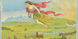
Presentation —"A Romp Through 19th Century Westward Expansion: From Lewis & Clark to Custer’s Last Stand" —In the 73 years between the Louisiana Purchase and the Battle of the Little Bighorn, the United States expanded from the Mississippi River to the Pacific Ocean, and, in the West, from essentially the 32nd parallel of north latitude to the 49th parallel. This expansion encompassed the enormous Louisiana Territory, Texas, the Oregon Country and the Spanish Southwest. At the beginning of the 19th century, this land was essentially unexplored by Americans, with inhabited areas occupied by Native Americans. J. C. will examine, with laser-like precision, barely allowing you to finish your dessert, how and why this expansion occurred, and what happened to the Native American population of the West as a result.
11 September 2019
Title: In the Footsteps of the Crime (Recovering a Map Masterpiece Stolen by E. Forbes Smiley)
Speaker: Dr. Ronald Grim (WMS)
Consultant (Map curatorship, historic maps)
Formerly Curator of Maps, Leventhal Map Center, Boston Public Library (BPL) (2005-2018)
Former Specialist in cartographic history, Library of Congress (LOC) (1982-2004); Former specialist in cartographic history, National Archives (1972-1982);
Ronald E. Grim was appointed Curator of Maps for the Norman B. Leventhal Map Center at the BPL in January 2005. This followed 33 years of US Government service with the nation’s two largest map collections, the National Archives and the LOC.
The crimes committed by E. Forbes Smiley against collections and libraries of historic maps in the first years of this century are well known. After his arrest, many maps were recovered, but many were not. Soon thereafter, Ron began his tenure at the Leventhal Map Center, one of Smiley’s many victims. He ordered a detailed inventory of their holdings, disclosing that a number of treasures requested by Smiley “for research” were missing. As years passed, he never gave up the search, and in 2015 his efforts paid off, resulting in the recovery of a map compiled by French explorer Samuel de Champlain. At the time it was for sale for $285,000. The Boston Globe described him as “eagle-eyed map curator, Ronald Grim.” Ron will recount the story of the hunt, the discovery, and the return of the map to the Leventhal collection.
WEDNESDAY 23 OCTOBER 2019
Title: Heavenly Maps
Speaker: Nick Kanas, M.D. WMS
Nick Kanas, M.D., is a Professor Emeritus (Psychiatry) at the University of California, San Francisco, and a Fellow of the Royal Astronomical Society. He has conducted NASA-funded research, has been an amateur astronomer for nearly 60 years, and has collected antiquarian celestial maps, books, and prints for over 35 years. He has given a number of talks on celestial cartography to amateur and professional groups, and he has written two books on the subject: Star Maps: History, Artistry, and Cartography, now in its 3rd edition, and Solar System Maps: From Antiquity to the Space Age.
People have observed the night sky since antiquity. The ancient Greeks placed the stars in a coordinate system that was based on celestial latitude and longitude, but they also organized them in a group of constellations that were viewed as allegorical representations of classical Greek heroes, heroines, and monsters. These images formed the backbone of constellation maps that appeared in stunningly beautiful star atlases of the 17th and 18th Centuries. Dr. Kanas will discuss this history of star mapping using striking images from antiquarian sources.
MONDAY 18 NOVEMBER 2019
Title: Maps of the Baltic States - Caught Between Empires
Speaker: Lars Grava, JD (WMS)
Mr. Grava works for the World Bank.
Mr. Grava will present selected antiquarian maps of the territories that are now the Baltic States of Latvia, Lithuania and Estonia, with a focus on his ancestral homeland of Latvia. The collection provides a fascinating insight into a turbulent geographical area which has been subject to the German Teutonic Knights, the Kingdom of Sweden, the Polish-Lithuanian Commonwealth, and the Russian Empire. Mr. Grava has over 400 maps from all these eras, from a collection begun by his father and carried on by himself.
SATURDAY 11 JANUARY 2020
The Washington Map Society has been invited to a special visit of Mount Vernon that includes several exclusive activities geared towards WMS members.
Itinerary:
10:00 AM: Library tour with a talk on Washington's globe and a visit inside the library vault to view cartographic artifacts (Cost: $10 per person)
11:15 AM: Guided tour of the Mansion (Cost: included with library tour)
12:30 PM: Buffet lunch at the Mount Vernon Inn Restaurant with fellow WMS members (Cost: $24 per person)
Please note that you are not required to attend all of the activities on the field trip, and you may simply join us for a portion of the itinerary if you prefer.
Advance registration is required for this event, and space is limited to the first 40 people. Due to these space limitations, each WMS member may bring one non-WMS guest. For more details and to register, please contact Eliane Dotson at president@wmsdc.org and indicate the name(s) of the attendee(s) and whether you will be attending all portions of the itinerary or only select activities. To pay by check, please make the check payable to Washington Map Society and mail to Peter Porrazzo, WMS Treasurer, 1924 Tysons Trace Dr, Vienna, VA 22182. If you would like to pay by PayPal or credit card, please indicate that in your registration email to Eliane and she will send you instructions. Please note that there is a $1 service fee for paying by PayPal or credit card.
FEBRUARY 2020
No Program due to typically poor weather.
The following two meetings cancelled:
THURSDAY 26 MARCH.
Time: 7:00 PM
Location: Naval Lodge Building, 330 Pennsylvania Avenue, Southeast, Washington DC
Title: Mapping the Transformation of the American Landscape during the 19th Century: The Price of Progress?"
Speaker: RONALD E. GRIM, PHD., Formerly Curator of Maps, Leventhal Map Center, Boston Public Library
This presentation is based on an exhibition that was developed by the Leventhal Map and Education Center and is currently on display at the Boston Public Library (online version at https://collections.leventhalmap.org/exhibits/25). This exhibition, entitled, America Transformed: Mapping the 19th Century, uses a variety of maps and related graphic objects to tell the story of how America’s physical and cultural geography changed during the 19th century. From a traditional interpretation of U.S. history, this transformation was viewed as progress, but in this discussion, we will ask at what price.
Contemporary 19th century maps are an ideal graphic device for telling this multifaceted story. Most maps capture one moment in time. By examining a selection of maps that document different time periods, geographic change over time becomes apparent. However, these maps reflect the biases of their creators, most of which were published by agencies of the federal government or commercial companies catering to profit making motives. Consequently, they tend to emphasize and glorify the superiority of European white culture at the expense of Native peoples and other minority groups. As the exhibition unravels these biases and explains the processes that affected change, the interpretation also includes the more unpleasant stories of dispossession of Native populations, exploitation of enslaved African laborers and other immigrant groups, and destruction of natural resources
The followiing presentation formerly to be given on March 26, 2020 will be delayed.
Title: Vacationing in Virginia, 19th Century Style: Plan of Fauquier White Sulphur Springs with Proposed Building Lots
Speaker: Cassandra Britt Farrell, Senior Map Archivist, Library of Virginia
Earlier this year, the Library of Virginia acquired a manuscript plan of Fauquier White Sulphur Springs. Cassandra Farrell will discuss her research regarding Fauquier White Sulphur Springs and the surveyors involved in the plat's creation. See http://exhibits.hsl.virginia.edu/springs/fauquier/
Date/Time: Thursday, 14 May 2020 @ 7:00 PM
Topic: "Vacationing in Virginia, 19th Century Style: Plan of Fauquier White Sulphur Springs with Proposed Building Lot"
Speaker: Cassandra Farrell, Senior Map Archivist at Library of Virginia and WMS Board Member
Earlier this year, the Library of Virginia acquired a manuscript plan of Fauquier White Sulphur Springs. Cassandra Farrell will discuss her research regarding Fauquier White Sulphur Springs and the surveyors involved in the plat's creation. For more information on the project, see http://exhibits.hsl.virginia.edu/springs/fauquier/ This meeting was originally scheduled for 26 March 2020 so we are thrilled that Cassandra agreed to reschedule it as a Zoom meeting.
Zoom Instructions
Zoom is a video-conferencing software that can be used from a desktop or laptop (Windows or Mac), tablet, or cellular phone. You do NOT need to create an account to join a meeting. If you are not familiar with using Zoom, we recommend that you review the helpful instructions and video tutorials available on their website. You can also join a "Test Meeting" from the Zoom website to practice and make sure that your video/audio are working properly. As a reminder, in order to join the WMS meeting, you must RSVP to John Docktor at washmap@gmail.com to receive the meeting ID and passcode.
How to Join a Meeting: https://support.zoom.us/hc/en-us/articles/201362193
THURSDAY 4 June 2020
Time: 7:00 PM
Location: Zoom
Title: Thinking in Space: The Case of Franklin D Roosevelt
Speaker: Andrew Rhodes, winner of the 2019 Dr. Walter W. Ristow Prize
Andrew Rhodes will present his Ristow Prize essay, "The Geographic President: How Franklin D. Roosevelt Used Maps to Make and Communicate Strategy." (See the cover story in The Portolan issue 107 (Spring 2020)). He will summarize the key points of his paper, illustrated with historical maps and photographs, and discuss some of the other cartographic history of the FDR administration. Andrew will also discuss how the FDR example relates to other research, including his recent article in Texas National Security Review, "Thinking in Space: The Role of Geography in National Security Decision-Making." Prior to this talk, the WMS will hold its annual Business Meeting.
Note: By choice of the presenter, this program was not recorded and is not available on-line.
GUEST LECTURE by KRIS BUTLER: July 1 @ 7:00 PM Eastern
Co-hosted by Washington Map Society, Rocky Mountain Map Society, Chicago Map Society, and New York Map Society
Date/Time: Wednesday, 1 July 2020 @ 7:00 PM
Topic: "Late 19th Century Drink Maps of the UK: A Virtual Journey and Beer Tasting"
Speaker: Kris Butler, past President of the Boston Map Society, a frequent attendee and presenter at the biyearly meetings of the International Conference on the History of Cartography, and a good friend of the late Bert Johnson
Registration Required: After registering, you will receive a confirmation email containing information about joining the meeting.
Kris Butler will take us on a virtual road trip across the United Kingdom in search of drink maps and historic beer styles. These lovely maps, created by temperance groups, were meant to shock people by showing in a flash the abundance of places to obtain alcohol in their towns. All of the maps have text on them encouraging people to take action -- usually by pressuring local magistrates to stop renewing the annually granted liquor licenses. And they are beautiful! In addition to seeing the maps and learning about a few historic beer styles, you will hear tales of unexpected adventures in tiny archives and grand libraries alike – including lost maps, missing librarians, hidden text, and surprise encounters.
Since we originally contemplated holding this meeting in a local pub, Kris’s presentation will have a slightly different format from what we are accustomed. She will supply us with a list of three historic beer styles that we can purchase and taste as she introduces them during her presentation. The beers that you purchase do not need to be exact, and if you are not a beer drinker, please feel free to indulge in any beverage of your choosing. The list of the three beers will be shared in a future email.
Professionally, Kris Butler is a lawyer, working as Senior Career Development Manager at the law firm of Holland & Knight in Boston. Her avocations include maps, beer brewing, and beer judging.
Date and Time: July 30, 2020 7:00PM EST
Subject: BENDING LINES: Maps and Data from Distortion to Deception.
Speaker: Garrett Dash Nelson, Curator of Maps and Director of Geographic Education at the Leventhal Map and Education Center at the Boston Public Library
Meeting Place: Online. Please email washmap (at) gmail.com to register.
Summary of Meeting:
Digital Exhibition: https://www.leventhalmap.org/digital-exhibitions/bending-lines/
WMS members: Click HERE to view three images from the presentation.
Nelson will introduce BENDING LINES, a new initiative of the Norman B. Leventhal Map and Education Center at the Boston Public Library (BPL). Bending Lines extends the category of “persuasive cartography” to interrogate a broader question of truth and belief as they are constructed through cartography and data visualization. Ranging from C16 attempts to reconcile Ptolemaic geography with the European discovery of the Americas to present-day maps that take a critical approach to data and GIS, Bending Lines explores how the reliability and accuracy of maps is always structured by social, political, and institutional context. The exhibition was originally planned for physical display at the Leventhal Map & Education Center’s gallery at the Boston Public Library, but, due to pandemic closures, was reimagined as a digital-first exhibition, accompanied with interactive material and remote activities.
Nelson is a historical geographer whose research focuses on the history of placemaking and planning in New England, with an emphasis on the role of maps in the creation of civic knowledge. He is also a cartographer and programmer with an extensive portfolio of projects that draws from fields like urban studies, historic preservation, and landscape architecture. He holds a BA from Harvard College, an MA from the University of Nottingham with a thesis on Frederick Law Olmsted in England, a PhD in Geography from the University of Wisconsin-Madison. He was most recently a Postdoctoral Fellow in the Society of Fellows and Department of Geography at Dartmouth College. His current book project is titled The Limits of Here: Contested Geographies of Community, Polity, and Place, which examines the history of unit-making across many geographic scales.
Alexander Gleason, Gleason’s New Standard Map of the World (1892): https://collections.leventhalmap.org/downloads/commonwealth:7h149v867?datastream_id=access800Richard Edes Harrison, for Newsmap, Land of the Setting Sun (1943): https://collections.leventhalmap.org/downloads/commonwealth:fn107c51t?datastream_id=access800
Maggie Owens, Rethinking Hazardous Beliefs (2020): https://collections.leventhalmap.org/downloads/commonwealth:rr173g30g?datastream_id=access800
THURSDAY 27 AUGUST 2020
Location: Zoom, 7:00 PM ET/6:00 PM CT/ 5:00 PM MT
Title: Mapping the Classroom: Teaching Geography and History in the 19th and 20th Century New England, based on a 2019 exhibit which is available online at : https://oshermaps.org/exhibitions/mapping-the-classroom
Speaker: Libby Bischof, Executive Director, Osher Map Library and Smith Center for Cartographic Education and Professor of History, University of Southern Maine (Portland). Click HERE for photo of Dr. Bischoff and two images.
In her richly illustrated lecture, Bischof will address the role of mapmaking in geography and history curricula in the 19th and 20th centuries, as well as the ways in which geography textbooks contributed to structural racism in primary and secondary education via "Races of Men" lessons and chapters. She will also talk about how the OML has developed a rich collection of educational materials related to geography and cartography.
Bio: Libby Bischof is the Executive Director of the Osher Map Library and Smith Center for Cartographic Education and Professor of History at the University of Southern Maine in Portland, Maine. She did her undergraduate and graduate studies at Boston College, receiving her Ph.D. in 2005. Her research and teaching interests focus on the cultural and social history of 19th century United States and the history of photography. Her regional interest is New England and Maine. She is co-author of two prize-winning books, Maine Moderns: Art is Seguinland (Yale University Press, 2011) and Maine Photographs: A History, 1840-2015 (Rowman and Littlefield, and Maine Historical Society, 2016).
THURSDAY 10 SEPTEMBER 2020 (In conjunction with the Library of Congress Geography and Map Division and Johns Hopkins University)
Location: Zoom, 7:00 PM ET/6:00 PM CT/ 5:00 PM MT
Title: Mapping Covid-19 from Phylodynamics to Contact Tracing
Speaker: John Hessler, Specialist in Computational Geography and Geographic Information Science at the Library of Congress and a Professor of Evolutionary Computation in the Graduate School of Advanced Studies at the Johns Hopkins University. Click HERE for sample slides.
Hessler will provide an introduction to the computational techniques and the algorithmic methods that cartographers and epidemiologists are using to map the spread and origins of COVID-19 (SARS-CoV-2 virus). He will look at methodologies for mapping the virus' nucleotide and amino acid mutations and examine how the virus spread to the United States, looking closely at the massive amounts of complex geospatial data generated by GISAID (originally known as Global Initiative on Sharing All Influenza Data). He will also talk about cell phone monitoring for contact tracing, touch on modern methods of sentiment analysis using geo-located tweets, and introduce the machine learning and spatial analysis algorithms that are helping scientists understand, in real-time, the spread and geospatial dynamics of the current pandemic.
Bio: John Hessler is Specialist in Computational Geography and Geographic Information Science at the Library of Congress and Professor of Evolutionary Computation in the Graduate School of Advanced Studies at the Johns Hopkins University. He is the founder of the New Geometries Lab, whose research applies geospatial data, with evolutionary computation, along with advances in bioinformatics, to solve complex spatial analysis problems, like mapping COVID-19. His publications cover a wide range of topics including The Naming of America: Martin Waldseemüller’ 1507 Map and Cosmographiæ Introductio (Library of Congress, 2008) and Map: Exploring the World (Phaidon, 2015).
TUESDAY 22 SEPTEMBER 2020 (Arranged by Rocky Mountain Map Society)
Location: Zoom, 7:00 PM ET/6:00 PM CT/ 5:00 PM MT
Title: A Mile High Above What Exactly?
Speaker: Derek van Westrum, Acting Gravity Section Chief, Table Mountain Gravity Observatory, Boulder, CO
Denver is the "Mile High City," and Colorado is famous for its collection of "14ers". But how exactly are such "heights above sea level" determined at locations so far from the sea? Westrum, a geodesist, will tell us that in the next couple of years, the United States is actually set to replace mean sea level with an entirely new basis for its height system. He will describe how the new system will work, why you're gonna love it, and what it might mean for some of those, um, lower 14ers. This is a general audience talk that explains datums, the new datum, and has some fun with what *might* happen to Sunshine Peak.
Bio: Derek van Westrum received his Ph.D. in physics from the University of Colorado and spent the next 15 years making instruments that measure changes in Earth's gravity. Since 2014, he has managed NOAA's gravity lab at the Table Mountain facility, north of Boulder - somehow finding the one division at NOAA that doesn't actually work directly with the Ocean or the Atmosphere.
TUESDAY 20 October 2020 (Arranged by Rocky Mountain Map Society)
Location: Zoom, 7:00 PM ET/6:00 PM CT/ 5:00 PM MT
Title: Prejudice and the Shaping of the American West
Speaker: Christopher W. Lane, Owner, The Philadelphia Print Shop West in Denver, CO
In 1800, what is today the American West was comprised of three political regions, all controlled by foreign powers. Over the next century, this area was absorbed into the United States and, through a series of ongoing changes, was broken into twenty-three political entities. This drawing and redrawing of borders was driven to a great extent by economic demands, but another factor which played as important and equal role in the shaping of the American West was prejudice: prejudice against Native Americans, Mormons, and African Americans.
During the nineteenth century, the United States’ mapmaking industry reached its maturity, with American-made maps published in large numbers and permeating many parts of the country’s political, economic and social life. Mapmakers did their best to keep their maps current as border changes were made, with maps reflecting every new configuration of territories and states, and sometimes even depicting configurations that never officially existed. The maps also played a role in how the borders were drawn, both through their cartographic configurations and their political or social content. This lecture will examine how nineteenth century maps reflected and effected prejudice’s role in the shaping of the American West.
Bio: Chris has worked in the antique print and map business for almost 40 years and has come to be recognized as one of the country’s experts in this field, as evidenced by his 22 year stint as print and map expert on PBS’s Antiques Roadshow. He has curated museum exhibitions and written several books, including the Ewell Newman Award winning Panorama of Pittsburgh, as well as numerous articles in books and magazines. He has also lectured around the country and overseas on topics such as antique maps, Currier & Ives, and historical prints. Since coming to Denver, he has made the history of western maps and views a particular focus, producing a number of articles on these topics and lecturing at the Denver Public Library and other local venues.
Click HERE for a few images.
THURSDAY 19 NOVEMBER 2020
Location: Zoom, 7:00 PM ET/6:00 PM CT/ 5:00 PM MT
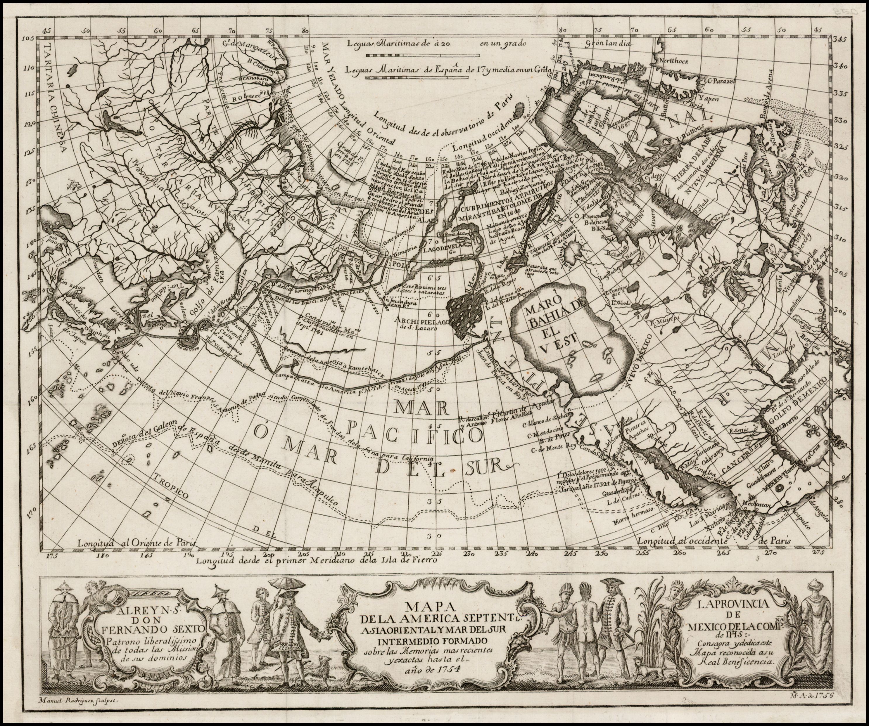
Title: Northern Seas: The Mapping of the North Pacific before the Voyages of James Cook.
Speaker: Katherine Parker, Research Officer for Barry Lawrence Ruderman Antique Maps, and Chair, WMS Walter W. Ristow Prize.
Before Cook’s third voyage in search of the Northwest Passage (1776-1780), few European ships had sailed north of the traditional Spanish galleon route; those that had were sparsely reported, as in the case of Bering’s Kamchatka expeditions, or dubiously reported, as in the case of the apocryphal Admiral de la Fonte. This presentation will focus on the geographic discourse about the North Pacific prior to Cook’s third voyage, with an especial emphasis on the period 1670-1776. Katie will also provide a short overview of the new map history network H-Maps, an international digital forum sponsored by the International Society for the History of the Map.
Bio: Katie is currently serving as the Chair of the Washington Map Society’s Walter W. Ristow Prize. She is also Associate Editor of the Hakluyt Society and Book Reviews Editor for the H-Maps Network. As a Ph.D. graduate in history from the University of Pittsburgh, her research interests focus on the intellectual and cultural history of Pacific exploration and early modern print culture with an emphasis on Britain. She is also interested in the history of the book, history of cartography, Pacific studies and history, British history, imperial history, and naval history, all within transnational frameworks.
Click HERE for an image of one of the maps to be discussed.
THURSDAY 3 DECEMBER 2020 (Arranged by Chicago Map Society)
Location: Zoom, 7:00 PM ET/6:00 PM CT/ 5:00 PM MT
Title: How Federal Government Redlining Maps Segregated America
Speaker: Linda Gartz, Chicago-based documentary producer, author, blogger, educator, and archivist
Summary: Please join Linda Gartz, for a Zoom discussion about her award-winning book, Redlined, and her discovery of the redlining maps used by the federal government to exclude African Americans from the middle-class dream of home ownership. Inspired by a trove of long-hidden family letters, diaries, photos, spanning the 20th century, Redlined interweaves a riveting family story with the history of redlining. Linda will display digitized versions of original redlining maps, share photos, read short excerpts from Redlined, and speak about the lasting impact of redlining maps that segregated America. Plenty of time for Q&A.
Bio: Six-time Emmy-honored Linda Gartz is a documentary producer. Her documentaries and TV productions have been featured on ABC, NBC, CBS, PBS, and Investigation Discovery, syndicated nation-wide. Her educational videos include Begin with Love, hosted by Oprah Winfrey and Grandparenting, hosted by Maya Angelou. Gartz’s articles and essays have been published in literary journals, online, and in local and national magazines and newspapers, including The Chicago Tribune. Born in Chicago, she studied at both Northwestern University and the University of Munich and has lived most of her adult life in Evanston, IL. She earned her B.A. and M.A.T. degrees from Northwestern. To learn more, go to www.LindaGartz.com.
Click HERE for three images related to the presentation.
5 JANUARY 2021
Location: Zoom, 7:00 PM ET/6:00 PM CT/ 5:00 PM MT/4:00 PM PT
Title: Mapping Maine: The Land and Its Peoples, 1677–1842
Speaker: Matthew H. Edney, University of Southern Maine and University of Wisconsin–Madison.
Edney will take us through the Osher Map Library and Smith Center for Cartographic Education’s current exhibition, which is their contribution to the marking of the bicentennial of Maine statehood in 1820. There is much to say about the formation and mapping of the land that became Maine, and much has already been said. The exhibition and this talk therefore focuses on the “mapping out” of the Wabanaki peoples by the English and then American colonizers, but also on the persistence of those peoples. Some reference is made to the Passamaquoddy but the OML collections allow a greater consideration of the Penobscot. The exhibition was postponed by the pandemic but opened to the public on September 12, 2020; an online version is available at: https://oshermaps.org/exhibitions/maine-bicentennial.
Dr. Matthew H. Edney (PhD 1990) is Osher Professor in the History of Cartography at the University of Southern Maine (Portland) and also director of the History of Cartography Project at the University of Wisconsin–Madison. He is author of many articles and books, most recently of Cartography: The Ideal and Its History and, edited with Mary Pedley, Cartography in the European Enlightenment, volume 4 of The History of Cartography. He is currently working on the history of the study of early maps; he blogs at mappingasprocess.net.
Click HERE for a couple of images related to the presentation.
SATURDAY 30 JANUARY 2021 (Gerrymandering and Congressional Redistricting, a two-hour program developed in conjunction with the Library of Congress Philip Lee Phillips Map Society and the Rocky Mountain Map Society).
Location: Zoom, 2:00-4:00 PM ET/1:00-3:00 PM CT/ 12:00 NOON-2:00 PM MT/11:00 AM -1:00 PM PT
First Presentation: Algorithmic Democracy: Supercomputers, NP-hardness & the New Science of Gerrymandering.
Speaker: John Hessler, Specialist in Computational Geography and Geographic Information Science at the Library of Congress and a Professor of Evolutionary Computation in the Graduate School of Advanced Studies at the Johns Hopkins University.
Summary: Gerrymandering has a long history in law, politics and cartography. Today however, with the use of specialized algorithms and supercomputers, it has become a mapping project very different from what it was in the 19th and early 20th centuries. This talk will give an introduction to the modern science of gerrymandering and highlight how massively parallel computation and supercomputers are giving rise to new forms of cartography and complex geospatial information based on the processing of huge amounts of census and social media derived data. These simulations are creating maps that reveal hidden patterns in voting behavior and have led to new and interesting forms of analysis and visualization that have spawned deep legal and technical questions concerning what actually constitutes a gerrymandered map. This talk will also introduce listeners to current technical, mathematical and computational questions about gerrymandering, to the effect the census has on maps produced by states, like Kansas and North Carolina, and will discuss the legal difficulties about how it is gerrymandering is measured, which were recently before the Supreme Court.
Bio: John Hessler is Specialist in Computational Geography and Geographic Information Science at the Library of Congress and Professor of Evolutionary Computation in the Graduate School of Advanced Studies at the Johns Hopkins University. He is the founder of the BIO-COMP Labs, whose research applies geospatial data, with evolutionary computation, along with advances in bioinformatics, to solve complex spatial analysis problems, like mapping COVID-19. His publications cover a wide range of topics including The Naming of America: Martin Waldseemüller’ 1507 Map and Cosmographiæ Introductio (Library of Congress, 2008) and Map: Exploring the World (Phaidon, 2015).
Second Presentation: What Can Mathematics Tell Us About Fairness for Redistricting?
Speaker: Jeanne Nielsen Clelland, Professor, Department of Mathematics, University of Colorado, Boulder.
Summary: As we approach the next round of legislative redistricting in 2021, we all hope that independent redistricting commissions in many states will draw districting plans that are as fair as possible. But what exactly do we mean by “fair”? There are many criteria to be considered (e.g., keeping communities of interest intact, maximizing competitive districts to the extent possible, protecting the influence of racial/ethnic groups, etc.), but how can we tell whether or not a particular plan does a “good” job of satisfying these criteria? In order to address this question, we need to somehow establish some kind of baseline for what is realistically achievable. This is not as easy as it sounds, and it can depend in surprising ways on how voters are distributed geographically around the state.
A promising recent approach to this question involves using computational and statistical tools to compare a specific districting plan to an “ensemble” consisting of a large number of randomly drawn, legally valid plans. This strategy can take into account the inherent political geography of a state in a way that simpler measures cannot, thereby giving important insight into the question of what a “fair” - or at least “typical” - districting plan might look like. These ideas have also begun to play a role in major court cases regarding partisan gerrymandering in North Carolina, Pennsylvania, and elsewhere.
Here in Colorado, our group (consisting of myself, Beth Malmskog and Flavia Sancier-Barbosa of Colorado College, Daryl DeFord of Washington State University, and some fabulous student researchers) has applied these methods in order to explore the current state of Colorado’s Congressional districts as of the 2018 election. Come to the talk and I’ll tell you what we learned!
Bio: Jeanne Clelland is a Professor of Mathematics at the University of Colorado - Boulder. She received her Ph.D. in 1996 from Duke University, and her main research interests are in differential geometry and applications of geometry fo the study of partial differential equations. She is the author of the textbook “From Frenet to Cartan: The Method of Moving Frames,” and she is the 2018 winner of the Burton W. Jones Distinguished Teaching Award from the Rocky Mountain Section of the Mathematical Association of America. She also studies applications of mathematical techniques to questions of redistricting and gerrymandering.
MONDAY 22 FEBRUARY 2021
(In conjunction with the California and Rocky Mountain Map Societies)
Location: Zoom, 7:00 pm ET/6:00 pm CT/5:00 pm MT/4:00 pm PT
Title: On the Brink of Disaster: George Washington and the American Revolution, 1775-1776
Speaker: Ronald S. Gibbs, former Chair of Obstetrics and Gynecology, University of Colorado School of Medicine, and Consulting Professor, Stanford University.
Gibbs will share the momentous ideas, great personalities, and seemingly incredible outcome of the early years of the American Revolution. Using 18th century maps to show the terrain and tactics, he will tell us about Gen. George Washington’s tough decisions, near disasters, and ultimate victories. The maps will include depictions of Bunker Hill, New York City, Westchester County, and Trenton. To tell one of the most thrilling stories in American history, he will supplement these great maps with portraits, prints and current day photos. This presentation is based on his most recent historical work, published in 2020 as an alternative history novel, The Long Shot: The Secret History of 1776. https://amzn.com/B085K12HD3 .
TUESDAY 23 MARCH 2021
(In conjunction with the Rocky Mountain Map Society)
Location: Zoom, 7:00 pm ET/6:00 pm CT/5:00 pm MT/4:00 pm PT
Title: “Make the Map All White”: Visual Strategies in the Eighteenth and Nineteenth Amendments
Speaker: Susan Schulten, Professor of History, University of Denver
Click HERE for detailed information.
Maps were essential tools for two of the most ambitious challenges to American law in the twentieth century: the suffrage and prohibition campaigns. Taking their cues from reformers of the nineteenth century, prohibitionists and suffragists used stark, persuasive maps to gain public support. Both movements began with regional strengths—suffrage in the west, prohibition in the south—and designed maps to leverage that regional power for their agendas. As suffrage and prohibition pivoted from state level campaigns to federal amendments after 1913, these maps amplified support across the entire nation. A closer look at the common slogan of the two campaigns, “Make the Map All White,” reveals the degree to which they also navigated—and exploited—racial and ethnic divisions in order to achieve their legislative and constitutional goals.